Fourteen Years Ago Tonight
On the evening of June 29, 2012, a line of severe thunderstorms that had been building since afternoon over Iowa and Illinois accelerated dramatically as it moved east, eventually racing across Indiana, Ohio, West Virginia, Virginia, Maryland, and Washington D.C. at speeds approaching 80 miles per hour. In less than 12 hours, it crossed ten states and 700 miles, killed 22 people directly and an estimated 34 more in the heat wave that followed, knocked out power to 4.2 million customers across the Mid-Atlantic and Ohio Valley, and became the most destructive thunderstorm event — measured in economic damage — in American history at that time.
The storm had a name that most Americans had never heard before: a derecho. By the morning of June 30, 2012, the word was on front pages and television broadcasts across the country, and millions of people who had spent a sweltering night without power in the middle of a heat wave were learning what kind of storm had done it to them.
What a Derecho Is
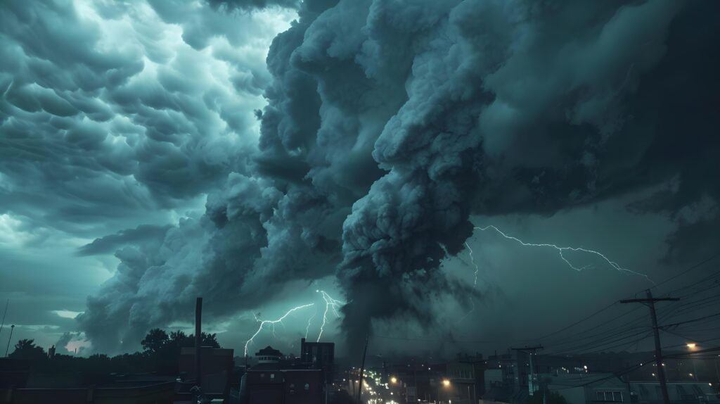
A derecho — the word comes from the Spanish for “straight,” in contrast to the rotating winds of a tornado — is a long-lived, fast-moving complex of severe thunderstorms that produces straight-line winds of damaging intensity along a path of at least 240 miles. Where a tornado’s damage is concentrated in a narrow swath and its winds rotate, a derecho produces widespread destruction across a broad corridor through purely linear wind action.
Derechos form when a line of thunderstorms develops a particularly efficient organization called a bow echo — a line of storms that bows outward in the direction of motion, driven by a powerful rear inflow jet of air that accelerates the forward movement of the system. The rear inflow jet descends from the mid-levels of the atmosphere into the back of the storm, accelerating as it reaches the surface and producing the extreme forward-directed wind gusts that characterize derecho damage. Gusts in strong derechos regularly exceed 80 mph and can reach hurricane force — 74 mph — or beyond.
The June 29, 2012 derecho was a particularly intense example of a progressive derecho — a type that develops over time as individual storm cells merge and organize, gaining intensity as they move. What began as a cluster of afternoon thunderstorms over Iowa became a coherent, accelerating system by evening, feeding on the extreme atmospheric instability of a day when surface temperatures had reached 105°F in some areas and the atmosphere was loaded with moisture and energy.
The Storm’s Track
The derecho initiated over Iowa and Illinois in the late afternoon of June 29 and moved east-northeast with increasing speed and intensity through the evening. By the time it crossed into Indiana around 8 p.m., it was producing wind gusts exceeding 80 mph across a corridor nearly 100 miles wide. Ohio experienced the storm between approximately 9 and 11 p.m., with the most intense gusts recorded at the leading edge of the bow.
West Virginia, which sits in complex mountain terrain that often disrupts organized storm systems, sustained some of the most severe damage of the entire event — the steep terrain and confined valleys channeled the wind in ways that amplified damage, and the state’s relatively older power infrastructure was particularly vulnerable. Parts of West Virginia remained without power for more than two weeks after the storm, with restoration complicated by damage in remote areas accessible only by roads that the storm had blocked with fallen trees.
The derecho reached the Washington D.C. metropolitan area between midnight and 1 a.m. on June 30, striking a region of 6 million people in the middle of the night when most were asleep. The combination of darkness, sleep, and the storm’s speed — arriving with little warning lead time — meant that many people experienced the damage only after the fact: waking to the absence of power, opening their doors to find trees down across streets and driveways, discovering that the familiar landscape of their neighborhoods had been dramatically rearranged overnight.
The Heat Wave That Made It Worse
The June 2012 derecho would have been a significant event in any weather context. It became a disaster because of its timing: the storm struck during a major heat wave that had been building for days across the Mid-Atlantic and Ohio Valley, with temperatures reaching 105°F in Washington D.C. and similar extremes across the affected region.
The 4.2 million customers who lost power on the night of June 29 did not regain it in a day or two. Restoration took one week for most customers and two weeks for the most affected areas. Those customers spent the worst heat wave in years without air conditioning — without fans, without refrigeration for food and medications, and in many cases without the ability to communicate about their situation because phone chargers require electricity.
The heat wave continued uninterrupted after the storm. The thunderstorm that knocked out the power brought no significant cooling — derechos produce wind damage but relatively little rainfall at any given point along their track, and the heat dome that had produced the extreme temperatures simply reasserted itself after the brief storm passage. People who had sheltered from the wind came out the next morning to 95°F temperatures and no power.
The deaths that followed the storm — estimated at 34 additional fatalities beyond the 22 direct storm deaths — were heat-related: elderly people in apartments without power and without the social connections that would have identified their need for assistance, in exactly the pattern that the Chicago Heat Wave of 1995 piece documented. The power outage converted a heat wave that would have been uncomfortable but survivable for most into a life-threatening situation for the most vulnerable.
The Damage
The physical damage from the June 2012 derecho was extraordinary in its geographic scope. An estimated 1 million trees fell or were significantly damaged across the affected region — not in the concentrated path of a tornado but spread broadly across 700 miles of forest, suburban neighborhoods, and urban parks. Fairfax County, Virginia reported more than 100,000 tree failures; Montgomery County, Maryland reported comparable numbers.
The power outages that resulted from this tree fall were not the simple single-point failures that most outages represent — a tree on a single line that can be cleared and repaired in hours. The scale and density of tree failures meant that virtually every distribution circuit in the affected area had multiple points of damage, requiring not just line repair but the physical removal of the downed trees before repairs could even begin. The logistics of restoring 4.2 million customer outages in summer heat, with a workforce that had to work in 100°F conditions and a supply chain for replacement equipment that was overwhelmed by the simultaneous demand, determined the pace of recovery more than the technical difficulty of any individual repair.
The economic damage — estimated at $2.9 billion in 2012 dollars — made the June 2012 derecho the costliest thunderstorm event in American history at that time. The combination of tree damage, infrastructure repair, food spoilage, business losses, and health impacts from the concurrent heat wave produced a total damage figure that exceeded many named hurricanes.
What Changed Because of It
The June 2012 derecho accelerated changes in utility vegetation management — the practice of trimming trees near power lines to reduce outage risk — that many utilities had been implementing slowly for years. The storm made the connection between tree-dense suburban development and power system vulnerability undeniable in a way that localized outage events had not.
It also raised questions about utility infrastructure resilience that remain unresolved: whether underground power lines — more expensive to install but immune to tree-fall damage — should replace aerial lines in high-density suburban areas, and what standards should apply to tree-planting near infrastructure. The cost-benefit calculation on undergrounding has not generally supported widespread deployment, but the 2012 derecho sharpened the terms of that discussion considerably.
The storm introduced derechos to public awareness in a way that will be familiar to anyone who follows severe weather: a catastrophic event that gives most people their first encounter with a meteorological term that specialists have used for decades. “Derecho” entered general American vocabulary on June 30, 2012, in the same way that “storm surge” entered it after Superstorm Sandy later that year — through direct, costly experience that no forecast discussion or educational campaign had previously achieved.
The Word You Now Know
Fourteen years after the June 2012 derecho, the word has become standard vocabulary in severe weather coverage. When derecho events occur — and they occur multiple times each summer across the United States — they are identified as such in forecasts, warnings, and news coverage in a way that would not have been universal before 2012.
The storm that introduced the word to millions of Americans also provided the most vivid possible illustration of what the word means: 700 miles of downed trees, 4.2 million dark homes, and a heat wave that had nowhere to go. The derecho of June 29, 2012 is the definition, illustrated at catastrophic scale, of why straight-line winds merit the same forecasting attention and public awareness as the rotating winds that have always dominated the severe weather narrative.