A Disaster Written Into the Region’s Infrastructure
In mid-July 1951, the Kansas and Missouri Rivers rose to levels that overwhelmed Kansas City’s industrial heart and much of the surrounding region, producing one of the costliest floods in American history to that point and permanently changing how the central United States thinks about river control. More than seven decades later, the flood’s fingerprints are still visible in the reservoirs, levees, and flood-control infrastructure that define the region’s relationship with its rivers today.
A Wet Spring Set the Stage
Like many of the Midwest’s most severe floods, the disaster of 1951 didn’t begin with a single storm. The spring of 1951 had already been unusually wet across Kansas and Nebraska, leaving soils saturated and small tributaries running high well before the flood’s defining rainfall arrived. That groundwork meant the region had little capacity left to absorb what came next.
In early July, a series of intense thunderstorm complexes moved across Kansas, dropping extraordinary rainfall totals across the Kansas River basin—in some locations, more than a foot of rain fell within about a week. The Kansas River and its tributaries, already elevated, had nowhere to send that volume of water except downstream, toward Topeka and ultimately Kansas City, where the Kansas River joins the Missouri.
Topeka and the Armourdale District Underwater
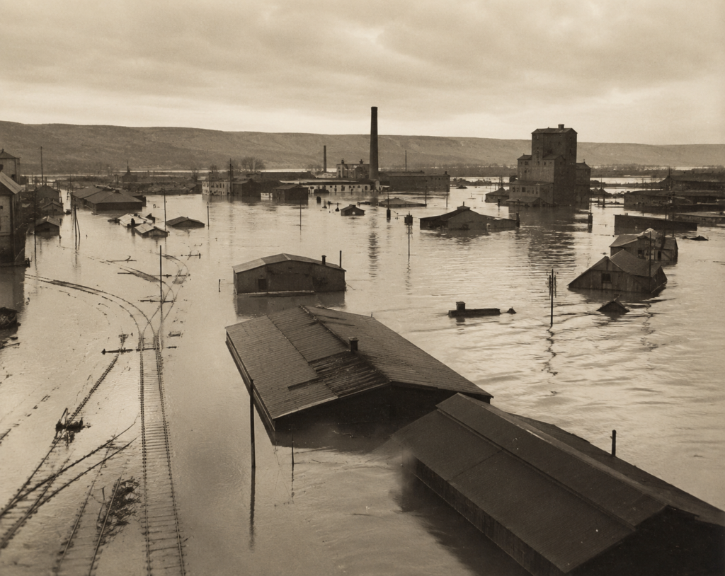
Topeka bore some of the flood’s earliest and most severe impacts, with the Kansas River overwhelming levees and inundating large sections of the city. But it was the Kansas City area—particularly the Armourdale and Fairfax industrial districts on the Kansas side, and the West Bottoms on the Missouri side—that suffered the flood’s most economically significant damage.
These low-lying districts sat directly in the floodplain and housed a dense concentration of stockyards, warehouses, rail yards, and manufacturing plants that formed a critical part of the region’s industrial economy. When the rivers crested in mid-July, water inundated these areas to depths that, in places, exceeded 20 feet, destroying buildings, equipment, and inventory on a scale that took years to fully recover from. Estimates placed total damage at roughly $1 billion in 1951 dollars—an extraordinary figure for the time, making it one of the most expensive natural disasters the country had experienced.
A Flood That Exposed the Limits of Existing Protection
Kansas City had built levees following earlier flood events, and those levees had provided a reasonable sense of security in the years leading up to 1951. The flood exposed how inadequate that protection actually was against a truly extreme event. Water levels exceeded what the existing levee system was designed to hold, and in some locations levees failed outright rather than being simply overtopped.
The flood also revealed how concentrated economic risk had become in the floodplain itself. Decades of industrial development had clustered enormous economic value in exactly the low-lying areas most vulnerable to river flooding, meaning that when the water arrived, the financial exposure was far greater than it would have been decades earlier, before that development occurred.
The Reservoirs Built in Its Aftermath
The 1951 flood became a primary catalyst for a substantial expansion of flood-control infrastructure across the Kansas and Missouri River basins in the following decades. Congress authorized and the Army Corps of Engineers constructed a network of reservoirs throughout the Kansas River basin specifically designed to capture and slowly release floodwater, reducing the peak flows that reach downstream cities like Topeka and Kansas City during major rain events.
This reservoir system, along with strengthened and extended levees around the metro area’s industrial districts, fundamentally changed the flood risk calculation for the region. Kansas City has experienced significant flood threats in the decades since 1951, but none have replicated the scale of destruction seen in that flood, in substantial part because of the flood-control infrastructure built specifically in response to what 1951 demonstrated was possible.
A Flood That Still Shapes the Region
The Flood of 1951 occupies a place in Midwestern weather history similar to other transformative disasters: an event so costly and so exposing of existing vulnerabilities that it directly reshaped the infrastructure and policy of the region for generations afterward. The reservoirs that now moderate the Kansas River’s flow, and the strengthened levees that protect Kansas City’s industrial districts, exist because of what happened in those few days in July 1951—a reminder that some of the most consequential weather events are the ones that force lasting changes to how communities build and prepare.