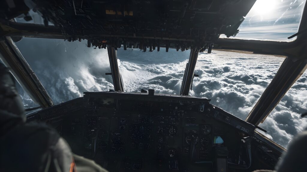
The People Who Fly Into Hurricanes on Purpose
When a hurricane is approaching the coast and meteorologists are trying to determine whether it will make landfall as a Category 2 or a Category 4, one of the most important data sources is not a satellite image or a radar screen — it is a modified military aircraft flying directly through the storm’s eyewall, measuring pressure, temperature, wind speed, and humidity at altitudes and locations that no ground-based instrument can reach.
Hurricane hunters — the crews of the NOAA Aircraft Operations Center and the U.S. Air Force Reserve’s 53rd Weather Reconnaissance Squadron — have been flying into Atlantic tropical systems since 1943, collecting the in-situ measurements that make the difference between a well-constrained forecast and one with dangerous uncertainty. Understanding what they do, how they do it, and why it matters connects the hurricane formation science (5/27), the NHC advisory products (7/5), and the fundamental challenge of forecasting storms over open ocean where no surface observations exist.
Why Aircraft Reconnaissance Is Still Necessary
Satellite imagery provides a continuous, global view of tropical systems that no aircraft program could replicate — every hurricane in the Atlantic basin is visible on satellite at all times, and modern geostationary satellites provide imagery every minute. Doppler radar from coastal stations covers approaching storms within several hundred miles of shore. So why, in an era of extraordinary remote sensing capability, are people still flying into hurricanes?
The answer is a measurement that satellites and radar cannot provide directly: the pressure at the storm’s center, measured at the surface. Central pressure is the most reliable single indicator of a hurricane’s intensity — lower pressure means stronger storm — and it cannot be accurately determined from space. Satellites measure cloud top temperatures and storm structure, from which intensity can be estimated through empirical relationships called the Dvorak technique. But these estimates carry uncertainty that can be the difference between a Category 3 and a Category 4 forecast — a difference that affects evacuation decisions for millions of people.
Aircraft can measure central pressure directly, by flying to the storm’s center and reading a barometer. They can also measure wind speeds directly through onboard instruments and through expendable sensors dropped into the storm, providing ground truth for the satellite and radar estimates that would otherwise carry more uncertainty.
A second critical measurement that only aircraft can provide is the storm’s three-dimensional wind field — the distribution of wind speeds and directions at multiple altitudes throughout the storm’s structure. This information is essential for understanding how the storm is organized, whether it is intensifying or weakening, and how it will interact with atmospheric features that affect its track and intensity. Dropsondes — small instrument packages deployed from the aircraft that fall through the storm while transmitting data — provide vertical profiles of temperature, humidity, pressure, and wind that no other observing system can replicate.
The Aircraft and Their Instruments
Two types of aircraft conduct Atlantic hurricane reconnaissance missions, operated by two different organizations with complementary roles.
The NOAA WP-3D Orion aircraft — two of which are operated by NOAA’s Aircraft Operations Center and affectionately named “Miss Piggy” and “Kermit” — are four-engine turboprop aircraft modified extensively for meteorological research. They carry an array of instruments that would not be recognizable in a commercial airliner: radar systems that look forward, downward, and to the sides to map the storm’s precipitation structure; instruments that measure temperature, humidity, and pressure in the ambient air; a tail Doppler radar that measures the wind field around the aircraft; and the launch systems for dropsondes. The WP-3Ds fly research missions designed to collect the scientific data that improves forecast models and storm understanding.
The WC-130J Hercules aircraft operated by the Air Force Reserve’s 53rd Weather Reconnaissance Squadron — the “Hurricane Hunters” — conduct operational reconnaissance missions: the regularly scheduled penetrations of Atlantic tropical systems that provide the central pressure measurements and storm position fixes that feed directly into NHC advisories. The WC-130Js carry a more focused instrument suite oriented toward operational measurement rather than research, and their missions are scheduled and predictable — typically flying into a tropical system every six hours when it poses a potential threat to land.
Both aircraft carry a dropsonde system — the key instrument for vertical profiling. A dropsonde is a small tube roughly 14 inches long containing pressure, temperature, and humidity sensors, a GPS receiver that tracks its position and derives wind speed and direction from drift, and a radio transmitter that sends data to the aircraft in real time as the sonde falls. Deployed through a chute in the aircraft’s belly, a dropsonde falls from aircraft altitude to the ocean surface in approximately 15 minutes, transmitting data continuously throughout its descent. A single mission may deploy dozens of dropsondes at strategic locations within and around the storm.
The Flight Profile: What It Actually Feels Like
A hurricane reconnaissance mission follows a specific flight pattern that is designed to efficiently collect the most valuable measurements. The standard pattern for a center fix — locating the storm’s center and measuring its central pressure — is called an alpha pattern or figure-four: the aircraft approaches the storm from outside, penetrates the eyewall to reach the eye, crosses through the eye, penetrates the opposite eyewall, exits the storm, repositions, and repeats from a different direction.
The eyewall penetration is the phase of the mission that has no parallel in civilian aviation. The eyewall — the ring of intense convection surrounding the hurricane’s calm eye — contains the strongest winds and most intense turbulence in the storm. Wind speeds in the eyewall of a major hurricane can exceed 150 mph; vertical air motion can produce updrafts and downdrafts that stress airframe structures; and the precipitation intensity in the eyewall is extreme.
Aircraft flying into eyewalls at the typical reconnaissance altitude of approximately 8,000 to 10,000 feet describe the penetration as a period of violent turbulence lasting roughly 5 to 15 minutes, depending on storm intensity and eyewall structure. Equipment not secured can become airborne. Crew members who are not strapped in are at risk of injury. Instrument readings change dramatically over seconds as the aircraft moves from the extreme conditions of the eyewall to the eerie calm of the eye.
The eye itself is one of the most striking atmospheric environments accessible to direct observation. In a well-developed major hurricane, the eye may be 20 to 40 miles across, with a wall of clouds rising on all sides to heights of 50,000 feet or more, completely clear air at the center with blue sky visible above, and the ocean surface visible below — sometimes disturbingly, displaying the massive waves generated by the surrounding storm in a circular pattern emanating from the center. Pilots who have flown into many hurricanes describe the eye consistently as one of the most visually dramatic environments they have ever experienced.
What the Data Produces
The measurements collected during a hurricane reconnaissance mission feed directly and immediately into NHC operations. Central pressure readings from aircraft fixes are transmitted in real time to the National Hurricane Center, where they are used to update the official intensity estimate within minutes of the aircraft measuring them. Dropsonde data is quality-controlled and transmitted to global weather data assimilation systems within hours of collection, improving the initialization of numerical forecast models for subsequent forecast runs.
The improvement in forecast accuracy from aircraft reconnaissance data is well-documented. Studies that remove reconnaissance data from model runs and compare the resulting forecasts to those made with full reconnaissance data show statistically significant improvements in track and intensity forecasts for storms that were sampled by aircraft — improvements that, when translated into reduced forecast uncertainty, support better-calibrated evacuation decisions and emergency management resource deployment.
The 2003 Hurricane Isabel reconnaissance is a frequently cited example: aircraft data revealed that Isabel’s eyewall had replaced — a common intensity cycle called eyewall replacement — in a way that significantly changed the storm’s structure and intensity trajectory. This structural information, only available from aircraft penetration, substantially improved the intensity forecast for Isabel’s landfall on the North Carolina coast.
The History: From 1943 to Now
The first deliberate flight into a hurricane occurred on July 27, 1943, when Army Air Corps Colonel Joseph Duckworth flew a single-engine AT-6 Texan trainer into a Gulf of Mexico hurricane on a bet with a British colleague who doubted the aircraft could survive the penetration. Duckworth flew into the storm twice that day — once with a navigator and once with a weather officer who insisted on experiencing it for himself — without instruments and without any of the structural reinforcement that modern reconnaissance aircraft carry. The flight established that controlled aerial penetration of tropical systems was possible and catalyzed the development of systematic hurricane reconnaissance.
The 53rd Weather Reconnaissance Squadron has flown continuous operational hurricane reconnaissance since 1944, through more than 80 hurricane seasons and thousands of individual storm penetrations. The aircraft, instruments, and data transmission systems have evolved enormously since Duckworth’s AT-6, but the fundamental mission — fly into the storm, measure what’s there, transmit the data — has remained constant.
Peak Season Is Now
Atlantic hurricane season peaks between mid-August and mid-October, with the statistical maximum of activity occurring around September 10. As the season enters its most active phase in the weeks ahead, the hurricane hunters’ schedule intensifies — aircraft may fly multiple missions per day into multiple storms simultaneously during active periods, with crews rotating to maintain the continuous six-hour reconnaissance cycle that provides the data stream NHC advisories depend on.
The next time a hurricane advisory is issued with a specific central pressure — “970 millibars at the center” — that number came from an instrument reading taken by someone who flew into the storm to get it. The precision of that measurement, and the forecast that depends on it, is the direct product of people doing one of the most unusual and consequential jobs in atmospheric science.