A Storm Whose Damage Came Largely After Landfall
Hurricane Katrina made landfall near the Louisiana-Mississippi border on the morning of August 29, 2005, as a large and powerful Category 3 hurricane. By meteorological measures alone, Katrina was significant but not unprecedented—several hurricanes in U.S. history have made landfall with comparable or greater wind intensity. What made Katrina one of the deadliest and most consequential disasters in modern American history wasn’t primarily the storm itself, but what happened in New Orleans in the hours and days that followed, when a system of levees and floodwalls designed to protect the city failed in multiple locations.
A City Built Below Sea Level, Protected by a Patchwork System
New Orleans sits largely below sea level, surrounded and threaded through by levees, floodwalls, and pumping stations designed to keep the surrounding water—Lake Pontchartrain, the Mississippi River, and various canals—out of the city. This system had been built and expanded incrementally over more than a century, by different agencies, using different design standards at different points in time.
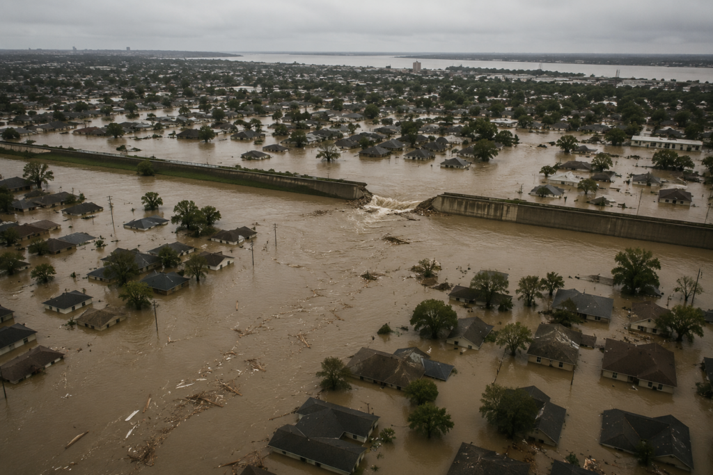
Katrina’s storm surge, pushed ashore by the hurricane’s large wind field, overwhelmed sections of this system. In the hours after landfall, floodwalls along several drainage canals failed catastrophically, and water poured into low-lying neighborhoods. Investigations conducted in the years afterward determined that many of these failures resulted not simply from the storm exceeding the system’s design capacity, but from design and construction flaws in the floodwalls themselves—some of which had been built on inadequate foundations that allowed them to shift and fail even before floodwater reached the levels they were rated to withstand.
The Lower Ninth Ward and the Human Cost
The floodwall failure along the Industrial Canal sent a wall of water into the Lower Ninth Ward, one of the city’s most severely affected neighborhoods, with a speed and force that gave many residents almost no warning to escape. Homes were swept from their foundations, and the neighborhood experienced some of the storm’s most concentrated loss of life.
Across the broader New Orleans metropolitan area and the Gulf Coast, Katrina and its subsequent flooding killed more than 1,800 people, displaced over a million residents, and caused an estimated $125 billion in damage, making it one of the costliest natural disasters in U.S. history. The scale of displacement was itself unprecedented for a domestic disaster—hundreds of thousands of residents never returned to the city, permanently reshaping New Orleans’s population and neighborhoods in ways still visible two decades later.
A Response That Became Its Own Story
The government response to Katrina, at every level, became almost as significant a part of the disaster’s legacy as the storm and flooding themselves. Delays in evacuation assistance, inadequate emergency shelter conditions—most visibly at the Superdome and the Convention Center, where tens of thousands of residents sheltered for days with insufficient food, water, and medical care—and a widely criticized coordination failure between local, state, and federal agencies drew sustained scrutiny in the disaster’s aftermath.
Katrina became a case study in emergency management failure specifically because so many of the problems weren’t attributable to the storm’s unpredictability, but to breakdowns in planning, communication, and resource allocation that had been identifiable risks well before the hurricane ever formed.
What Changed Because of Katrina
In the years following Katrina, the Army Corps of Engineers undertook a massive rebuilding of New Orleans’s flood protection system, including new floodwalls built to significantly higher standards, upgraded pumping stations, and a large surge barrier constructed at the mouth of some of the canals most implicated in the original failures. FEMA and emergency management agencies at multiple levels of government restructured evacuation planning, shelter protocols, and interagency coordination procedures based directly on documented Katrina failures.
Katrina also reshaped how the insurance industry and coastal communities think about storm surge risk specifically, separate from wind risk, since so much of the storm’s damage came from water rather than wind—a distinction that has influenced flood insurance policy and coastal development standards in the two decades since.
A Storm That Exposed More Than It Created
Katrina’s legacy is defined less by the hurricane’s meteorological characteristics than by what it revealed: aging infrastructure built to inconsistent standards, emergency response systems unprepared for a disaster of that scale, and a city’s vulnerability that had been documented by engineers and researchers years before the storm ever formed. Two decades later, Katrina remains the reference point for what happens when a serious but not extraordinary storm meets infrastructure and planning that isn’t equal to the risk a coastal city actually faces.