A Massive Storm That Threatened the Entire East Coast
In September 1999, Hurricane Floyd approached the southeastern United States as an enormous, powerful hurricane, its wind field so large that forecasters projected it could affect a significant portion of the East Coast regardless of exactly where it made landfall. This uncertainty, combined with the storm’s sheer size and intensity, prompted what was at the time the largest peacetime evacuation in American history, and Floyd’s subsequent inland flooding proved that the caution, while logistically chaotic, was largely justified.
An Evacuation on an Unprecedented Scale
As Floyd approached, officials across Florida, Georgia, South Carolina, and North Carolina ordered evacuations covering roughly 3 million people, a scale that overwhelmed the region’s highway infrastructure in ways that became a case study in the challenges of large-scale evacuation logistics. Interstate highways, particularly in Florida and Georgia, became parking lots as evacuees attempted to move inland simultaneously, with some drivers reporting trips that normally took a few hours stretching to twelve hours or more.
This traffic crisis prompted a significant reassessment of hurricane evacuation planning in the years that followed, including the adoption of contraflow lane reversal systems—converting inbound highway lanes to outbound use during mass evacuations—which several states subsequently implemented specifically in response to the lessons Floyd’s evacuation exposed.
A Storm That Ultimately Spared Florida
After the massive evacuation effort, Floyd’s actual track shifted northward, sparing Florida the direct hit that had prompted such an extensive evacuation there. While this outcome was, from a pure damage perspective, fortunate for Florida residents, it also became an early example of the “cry wolf” dynamic that complicates hurricane evacuation compliance—storms that prompt major evacuations but ultimately track away from a specific area can make residents more skeptical of future evacuation orders, even though the uncertainty that justified the original evacuation call was entirely legitimate given the information available at the time.
The Real Disaster Was Inland, Not at the Coast
Floyd made its actual landfall near Cape Fear, North Carolina, as a Category 2 hurricane—a significant but not historically extreme storm by wind measurement alone. The genuine catastrophe came from what happened after landfall: Floyd stalled somewhat as it moved across eastern North Carolina, dropping extraordinary rainfall totals, in some areas exceeding 20 inches, onto a region that had already been saturated by Hurricane Dennis just weeks earlier.
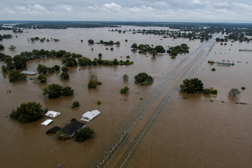
This combination—an already-saturated landscape meeting an enormous new rainfall total—produced catastrophic flooding across the eastern part of the state, particularly along the Tar and Neuse River basins, where flood crests reached levels that exceeded any previously recorded flood in the region’s history, in some cases by several feet.
A Flood That Killed Far More People Than the Storm’s Winds
Floyd’s flooding killed more people than its winds, storm surge, or any other direct hurricane hazard—the vast majority of the storm’s roughly 50 U.S. fatalities resulted from inland freshwater flooding rather than coastal impacts. Entire towns in eastern North Carolina found themselves isolated by floodwater for days, with some communities accessible only by boat or helicopter as roads disappeared beneath water that, in several towns, reached the rooflines of single-story homes.
The flooding also created a significant public health and environmental crisis, as floodwater inundated numerous large-scale hog and poultry farming operations common in the region, releasing animal waste into the floodwater and creating substantial water contamination concerns across the flooded area that complicated both the immediate emergency response and the longer recovery process.
What Floyd Changed About Hurricane Risk Perception
Floyd became one of the clearest historical examples supporting what has since become a well-established principle in hurricane preparedness: a storm’s category and coastal wind intensity don’t determine its overall danger, and inland flooding from rainfall can pose a threat as severe as, or more severe than, coastal storm surge, even in a storm that never reaches major hurricane intensity at landfall. This lesson directly influenced how the National Weather Service and emergency management agencies communicate hurricane risk today, with far greater emphasis now placed on rainfall and inland flood forecasting alongside traditional wind-based intensity measures.
Floyd’s evacuation logistics also prompted lasting infrastructure and planning changes, with several states adopting improved contraflow evacuation procedures and more sophisticated regional coordination protocols specifically informed by the gridlock Floyd’s evacuation produced.
A Storm Remembered for What Happened After Landfall
Hurricane Floyd’s legacy rests less on its wind intensity at landfall and more on two separate lessons it delivered: the genuine logistical difficulty of evacuating millions of people ahead of an uncertain storm track, and the sobering reminder that a hurricane’s rainfall, not simply its wind category, can produce the deadliest and most widespread damage of the entire event.