This Is Not Ordinary Summer Heat
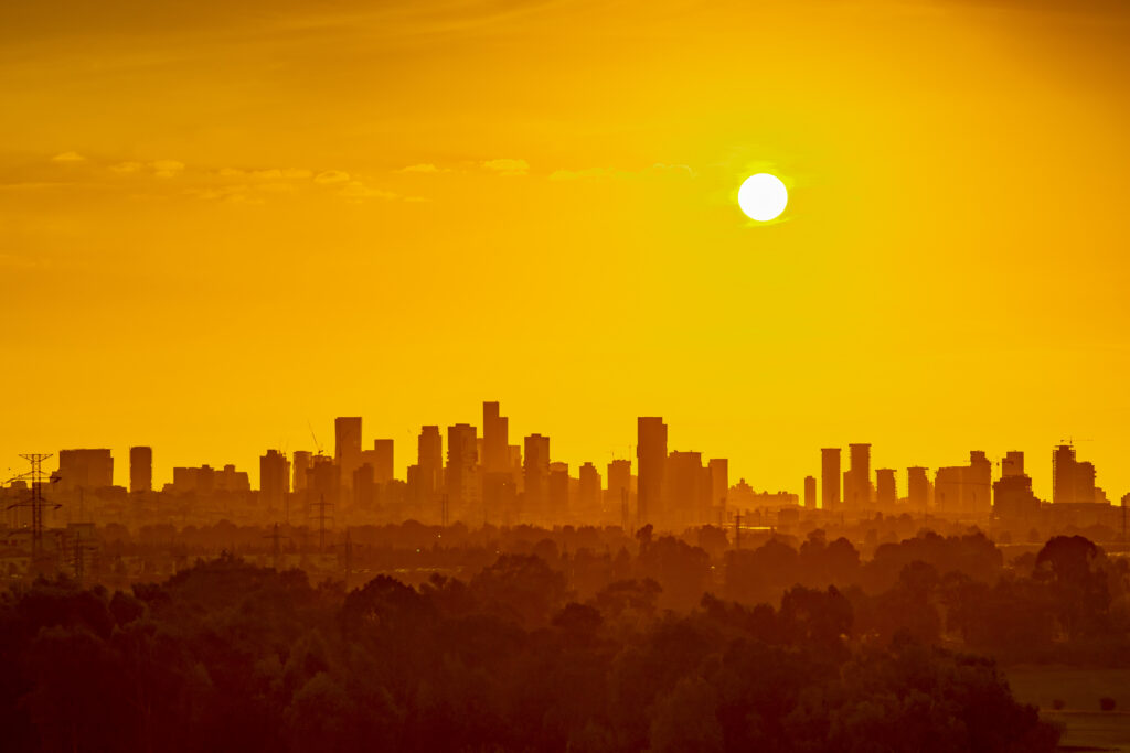
A significant heat wave is settling over the East Coast this week, and it deserves more than passing attention. Heat is the deadliest weather hazard in the United States — more lethal annually than tornadoes, hurricanes, and floods combined — and the specific conditions driving this event are producing temperatures and heat indices that go well beyond what a typical July day delivers. Understanding what is causing the heat, how long it will last, and who is most at risk is the foundation of managing it safely.
What’s Driving the Heat Wave
The heat wave affecting the East Coast this week is the product of a strengthened and westward-displaced Bermuda High — the large subtropical high-pressure system over the Atlantic that, as covered in the 7/13 Weather Daily piece, controls summer weather across the eastern United States. When the Bermuda High expands westward, its clockwise circulation pumps exceptionally warm, moist air northward from the Gulf of Mexico and subtropical Atlantic, while simultaneously suppressing the cloud cover and precipitation that would otherwise moderate temperatures.
The descending air of the high-pressure system warms as it sinks — the same adiabatic warming described in the drought science piece — producing surface temperatures that exceed what the season alone would deliver. Clear skies allow maximum solar radiation to reach the ground unimpeded, surface temperatures climb through the afternoon, and the urban heat island effect amplifies conditions in every city along the corridor.
What makes this event particularly intense is the overnight component. Overnight lows across the affected region are forecast to remain in the mid-70s to low 80s°F — elevated enough that the body cannot recover from daytime heat stress before the next day’s heat builds. As the historical heat wave pieces in this series have documented, the overnight low is often more important than the daytime high in determining heat event mortality: it is the failure of overnight recovery, accumulated over multiple days, that produces the physiological crisis that kills.
The Heat Index: What It Actually Feels Like
Temperature alone understates this event. The combination of high temperatures and the elevated humidity that the Bermuda High’s moisture flow delivers produces heat index values — the “feels like” temperature that accounts for humidity’s impairment of sweat evaporation — that will significantly exceed the air temperature readings.
On the peak days of this event, heat index values across portions of the Mid-Atlantic and Northeast are forecast to reach 105°F to 115°F in some locations. At these levels, the National Weather Service classifies conditions as dangerous for all groups — not just the traditionally vulnerable. Prolonged outdoor exposure or strenuous outdoor activity at these heat index values can produce heat exhaustion or heat stroke in healthy adults within a relatively short period.
The heat index exceeds the air temperature most dramatically in the afternoon, when both temperature and humidity are elevated simultaneously. Morning heat index values are modestly lower because overnight humidity rise occurs without the temperature component — the same phenomenon that produces high relative humidity readings on cool mornings, as covered in the humidity and dew point piece.
Who Is Most at Risk
Every significant heat event concentrates its lethality in specific populations, and this event is no exception. The people most at risk during this East Coast heat wave are:
Elderly people living alone, particularly in older housing stock without central air conditioning. The social isolation and physiological vulnerability that characterized the 1995 Chicago and 1980 Kansas City heat wave deaths is as present on the East Coast as anywhere. If you have an elderly neighbor or family member living alone, check on them today and tomorrow — not by phone, but in person, so you can assess their environment and their condition.
People without air conditioning, who are concentrated disproportionately in lower-income urban neighborhoods already amplified by urban heat island effects. The redlining-to-heat-island connection documented in the 7/14 urban heat island piece is directly relevant: the neighborhoods experiencing the highest temperatures are frequently those with the least access to private cooling. Know where your city’s cooling centers are and be prepared to share that information.
People working outdoors, whose heat safety needs were covered in the 7/9 outdoor worker heat safety piece. This event is exactly the kind of sustained heat with elevated overnight lows that makes occupational heat illness most dangerous — workers who haven’t recovered overnight are starting each day already heat-stressed.
Infants and young children, who cannot regulate their own thermal environment, cannot communicate distress effectively, and should never be left in vehicles under any circumstances during a heat wave. A car in direct sun during this event will reach lethal temperatures within minutes.
People with cardiovascular conditions, whose specific vulnerability was covered in the 7/19 cardiovascular health piece. The sustained heat and elevated overnight lows of a multi-day event impose a continuous elevated cardiac workload that pushes the most vulnerable hearts toward their limits.
Practical Actions for the Next 72 Hours
The heat wave’s peak is expected over the next two to three days. The actions that matter most during this window:
Stay in air-conditioned spaces during peak heat hours. The period from roughly 11 a.m. to 7 p.m. represents the highest heat index conditions of each day. Minimize outdoor exposure during this window and seek air-conditioned environments — your home if it has AC, a library, a mall, a community cooling center — for the most vulnerable members of your household.
Hydrate proactively. Drink water before you feel thirsty. The thirst signal lags behind actual hydration status by the time it registers, meaning thirst indicates you are already meaningfully dehydrated. In heat wave conditions, drink at least a cup of water every hour regardless of whether you feel thirsty, more if you are active or outdoors.
Check on vulnerable neighbors today. Don’t wait until someone is in crisis. A proactive check-in — a knock on the door, a brief visit to confirm someone has access to cooling and is drinking water — catches heat stress before it becomes heat stroke. The neighbor who doesn’t answer their door warrants more concern, not less.
Know the heat stroke signs. Confusion, agitation, slurred speech, loss of consciousness, or seizure after heat exposure indicate heat stroke — a medical emergency. Call 911 immediately and begin cooling the person while waiting for emergency services: move them to cool air, apply cool water to the neck, armpits, and groin, remove excess clothing. Do not leave them alone.
Limit strenuous outdoor activity. If outdoor activity is necessary, schedule it before 9 a.m. or after 7 p.m. when heat index values are lower, wear light-colored loose clothing, and plan rest breaks in shade or air-conditioning.
This Will Pass — But Not Immediately
The heat wave is expected to break when a frontal system pushes through the region later in the week, bringing lower temperatures and humidity and the post-frontal air clarity that produces the kind of July days the East Coast does well. Until that front arrives, the conditions are genuinely dangerous, and the people who manage them safely are those who treat them with appropriate seriousness — not panic, but the same deliberate preparation that this series has documented as the difference between heat events that are uncomfortable and heat events that are fatal.