148 Tornadoes in 18 Hours
On April 3 and 4, 1974, a tornado outbreak of unprecedented scale swept across the eastern United States. In 18 hours, 148 tornadoes touched down across 13 states — from Alabama to Ontario, Canada — killing 330 people, injuring more than 5,000, and leaving a trail of destruction that defied anything meteorologists had previously documented. Seven of the tornadoes were rated F5, the maximum intensity on the Fujita scale — the most F5 tornadoes ever recorded in a single event.
The Super Outbreak, as it became known, didn’t just break records. It fundamentally changed how scientists understood tornado outbreaks, how meteorologists classified storm intensity, and how the United States approached the challenge of warning millions of people simultaneously when the atmosphere produces the most violent weather it is capable of generating.
The Atmosphere That Day
The setup for the Super Outbreak had been visible in the large-scale weather pattern for days before the event. A powerful upper-level trough was digging into the central United States, and ahead of it, an extraordinarily moist and unstable airmass was being drawn northward from the Gulf of Mexico. Surface dew points across Alabama and Georgia reached the low 70s — values more typical of July than early April. The jet stream was positioned to provide extreme wind shear throughout the mid-levels of the atmosphere.
The Storm Prediction Center’s predecessor, the Severe Local Storms unit, had recognized the potential for a significant outbreak and issued watches covering much of the threatened area. What couldn’t be anticipated was the scale of what would develop — that the atmosphere had assembled a combination of ingredients so extreme that it would produce not one or two major tornadoes but continuous, simultaneous tornado activity across a corridor spanning more than 2,500 miles.
The storms developed in Alabama and Mississippi in the early afternoon of April 3 and tracked northeast through the evening and overnight hours, with new storms continuously initiating to the southwest as earlier storms moved out of the region. By the time the outbreak concluded in the early morning hours of April 4, it had left a mosaic of destruction across portions of Alabama, Georgia, Tennessee, Kentucky, Ohio, Indiana, Michigan, Illinois, Mississippi, Virginia, West Virginia, New York, and Ontario.
The Storms That Defined the Outbreak
Several individual tornadoes within the Super Outbreak stand out for their intensity, path length, or the communities they struck.
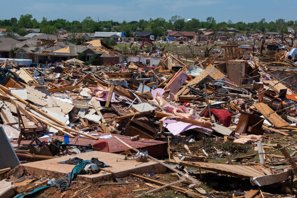
The Xenia, Ohio tornado was the outbreak’s most devastating single storm in terms of human impact. The F5 tornado struck the city of 25,000 people in the late afternoon of April 3, killing 34 people and destroying more than 1,000 structures. The tornado’s path cut directly through the heart of Xenia, destroying the high school gymnasium where hundreds of students had been sheltering just moments before the storm arrived. Nine schools in the city were destroyed or severely damaged. Downtown Xenia was effectively eliminated, with blocks of commercial buildings reduced to rubble. The Xenia tornado became the defining image of the outbreak — photographs of the devastated downtown were reproduced widely and introduced the scale of the event to a national audience.
The Guin, Alabama tornado — rated F5 — killed 30 people in a rural community, representing one of the highest single-storm death tolls of the outbreak. The Brandenburg, Kentucky tornado crossed the Ohio River and struck both the Kentucky and Indiana sides of the river valley, killing 31 people across two states in a single continuous track.
Several tornadoes in the outbreak produced tracks exceeding 100 miles, an extraordinary achievement even by the standards of long-track tornado events. The simultaneous occurrence of multiple long-track violent tornadoes — a scenario that had never been documented at this scale — overwhelmed warning systems, emergency management resources, and the conceptual framework that meteorologists had used to understand tornado outbreaks up to that point.
Ted Fujita and the Scale That Came From It
The Super Outbreak became the event that defined the Fujita scale — the intensity classification system for tornadoes that remained the standard in the United States for more than three decades.
Tetsuya Theodore “Ted” Fujita, a meteorologist at the University of Chicago, had proposed a wind damage scale in 1971 that related structural damage to estimated wind speed, ranging from F0 (minimal damage, winds 40-72 mph) to F5 (incredible damage, winds 261-318 mph). The scale had been in limited use but hadn’t been applied to a major outbreak systematically.
Following the Super Outbreak, Fujita led a comprehensive damage survey of the entire affected area — a massive field effort involving aerial surveys, ground inspections, and interviews with survivors. The survey documented damage patterns at hundreds of locations across 13 states and allowed Fujita to map the intensity of each tornado along its entire path with unprecedented detail. The 1974 Super Outbreak became the definitive dataset that validated and refined the Fujita scale, establishing the relationship between specific damage indicators and tornado intensity that remained the basis for tornado classification until the Enhanced Fujita scale replaced it in 2007.
The survey also revealed something remarkable about the outbreak’s F5 tornadoes: the damage they produced was qualitatively different from lower-rated storms, with steel-reinforced concrete structures showing damage that helped establish the upper boundaries of the scale. The data collected from 1974 informed tornado-resistant construction standards and building code development for decades.
What the Outbreak Exposed About Warning Systems
The Super Outbreak severely tested the tornado warning infrastructure of 1974 — and found it inadequate in ways that drove significant investment in the years that followed.
The simultaneous development of dozens of tornado-warned storms across a 13-state area stretched every available resource. Radio and television broadcasts could carry only so many warnings at once; in some areas, the sheer number of simultaneous watches and warnings created confusion rather than clarity. Many communities received their first warning only after a tornado had already struck neighboring areas.
Communication between the Storm Prediction Center, local National Weather Service offices, and local emergency management was far less coordinated than modern systems. The concept of a unified severe weather warning chain — with the SPC issuing watches, local offices issuing warnings, and emergency management executing response — existed in framework but lacked the operational coordination and technology to function efficiently during a multi-state outbreak of this magnitude.
The outbreak accelerated investment in several areas that became critical components of the modern warning system: expanded weather radio networks that could broadcast warnings to specific geographic areas, improved coordination protocols between national and local forecasting offices, and the research that would eventually produce the NEXRAD Doppler radar network whose velocity detection capability could identify rotation in individual storms within the larger outbreak environment.
The 2011 Super Outbreak: History Echoing
The 1974 Super Outbreak held the record for the largest tornado outbreak in history for 37 years, until the April 25-28, 2011 Super Outbreak produced 362 tornadoes across the southeastern and central United States, killing 324 people.
The comparison between 1974 and 2011 is instructive about both how much has changed and how much hasn’t. The 2011 outbreak was more than twice as large in terms of tornado count and occurred in an era of Doppler radar, improved forecast models, and widespread smartphone alerts. Yet the death toll was comparable to 1974 — 324 versus 330 — a fact that reflects both the larger scale of the 2011 event and the genuine limits of warning systems when the atmosphere produces extreme outbreaks over heavily populated areas.
What the comparison also shows is that modern warning systems prevented casualties on a scale that would have been catastrophic under 1974 conditions. The 2011 outbreak produced multiple EF5 tornadoes, including the Joplin, Missouri tornado of May 22 that killed 161 people and the Tuscaloosa-Birmingham tornado of April 27 that killed 64. Under 1974-era warning infrastructure, the 2011 death toll would almost certainly have been dramatically higher.
A Benchmark That Endures
The 1974 Super Outbreak remains a benchmark in American meteorological history — the event that established what the atmosphere is capable of producing when conditions are sufficiently extreme, that validated the tools used to classify what tornadoes do, and that exposed the gaps in warning infrastructure that the subsequent decades worked to fill.
Every spring, when the atmosphere assembles the ingredients that produce major tornado outbreaks — extreme instability, abundant moisture, powerful wind shear, a vigorous jet stream — meteorologists look at the patterns developing in their models and measure them against what April 3-4, 1974 produced. It remains the standard against which outbreak potential is assessed, fifty years after the storms that defined it.