The Clouds of April Are Different—and Here’s Why
Look up on a spring afternoon and the sky is doing something it rarely did all winter. Flat-bottomed clouds build upward with startling speed, their tops billowing into cauliflower shapes that climb thousands of feet in the space of an hour. By early afternoon, some of them have grown tall enough to cast shadows that cool the ground beneath them. By late afternoon, the biggest ones have darkened at the base and begun to produce rain — or worse.
Spring clouds are genuinely different from winter clouds, and the difference is visible to anyone who pays attention. Understanding why spring produces such vertical, dramatic cloud development reveals the same atmospheric physics that drives spring’s severe weather — and gives you a practical way to read the sky and understand what’s coming before the forecast app on your phone has caught up.
All Clouds Start the Same Way
Every cloud, regardless of type, forms through the same basic process: warm, moist air rises, cools as it ascends, and eventually reaches a temperature at which its water vapor condenses into tiny liquid droplets. Those droplets, too small and light to fall as rain, remain suspended in the air and become visible as cloud.
The altitude at which this condensation occurs — called the lifting condensation level — determines where cloud bases form. When you look at a field of puffy cumulus clouds on a spring afternoon and notice that their flat bottoms are all at roughly the same height, you’re seeing the lifting condensation level made visible: a consistent altitude at which rising air across the entire area is cooling to its dew point simultaneously.
What happens above that flat base — how high the cloud builds, whether it stays benign or grows into a storm — depends on the instability of the atmosphere above it.
Instability Is What Makes Spring Clouds Grow Tall
In a stable atmosphere, a parcel of air that rises and cools quickly becomes cooler than the surrounding air. Cooler air is denser than the surrounding air, and the parcel stops rising on its own — the cloud stops building and spreads out horizontally into the flat, layered clouds called stratus or altostratus that characterize many winter days.
In an unstable atmosphere, the situation reverses. Rising air remains warmer — and therefore lighter — than the air surrounding it, even as it climbs higher. This buoyancy keeps the air parcel rising on its own, like an elevator with no upper floor, and the cloud keeps building vertically. The greater the instability, the more powerful the updraft, and the taller the cloud can grow.
Spring maximizes atmospheric instability through a specific temperature profile. The strengthening spring sun heats the ground rapidly, warming the air near the surface to temperatures significantly higher than the air thousands of feet above, which is still cold from winter. This steep temperature gradient — warm at the bottom, cold aloft — is the definition of atmospheric instability. The greater the temperature difference between surface and upper atmosphere, the more vigorously surface air rises when triggered, and the taller the resulting clouds.
Reading the Clouds: From Cumulus to Cumulonimbus
The spring sky offers a readable progression of cloud development that tells you something meaningful about how the afternoon is likely to unfold.
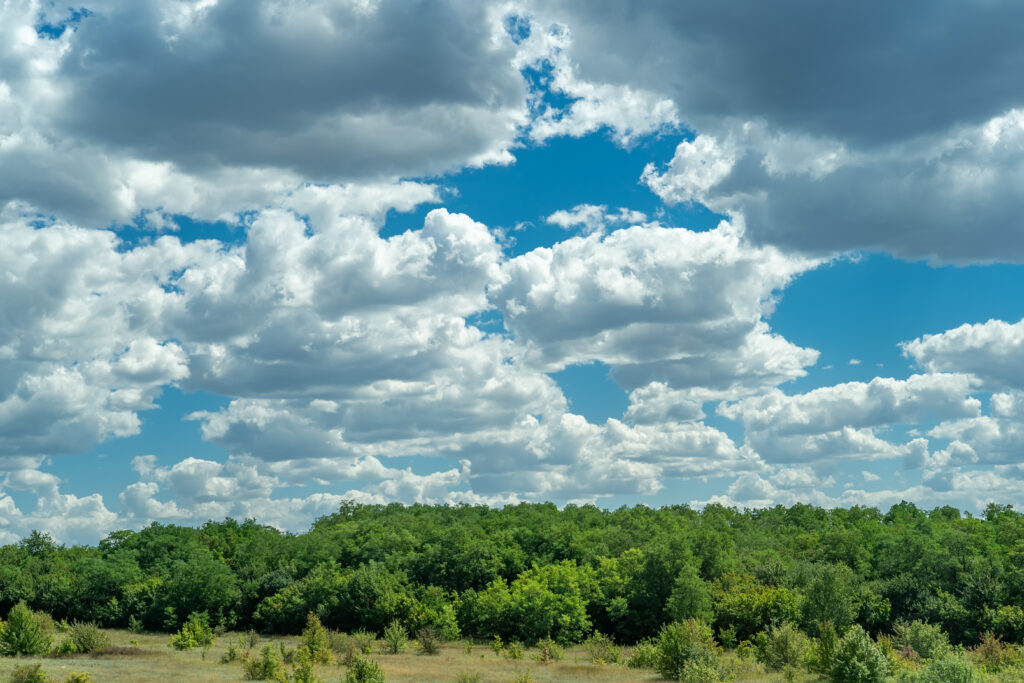
Fair-weather cumulus are the cheerful, popcorn-like clouds of a pleasant spring morning — white, well-defined, with flat bases and rounded tops that don’t extend more than a few thousand feet. They form as morning heating generates small thermals that rise and condense but don’t have enough energy to build further. These are harmless and actually indicate a reasonably stable airmass in the middle and upper levels of the atmosphere.
Cumulus mediocris are the next stage — taller cumulus clouds whose vertical development has clearly exceeded their horizontal extent. The tops are still white and crisp, but they’re building noticeably. These indicate increased instability and are worth watching if the atmosphere has the ingredients for stronger development.
Towering cumulus, sometimes called cumulus congestus, are the clouds that demand attention. Their vertical extent dwarfs their width, their tops are still brilliant white and cauliflower-textured, and they may be producing light rain showers. When you see towering cumulus building rapidly on a spring afternoon — especially if they’re growing visibly taller as you watch — the atmosphere is telling you that significant storm development is possible within the next hour or two.
Cumulonimbus is the fully developed thunderstorm cloud, and it is unmistakable. The top, which has risen into the upper troposphere where temperatures are so cold that water droplets freeze into ice crystals, loses its cauliflower texture and spreads into the distinctive anvil shape — a flat, fibrous, ice-crystal plume that extends downwind from the storm’s top. The anvil marks the tropopause, the boundary between the lower and upper atmosphere where temperature stops decreasing with altitude and rising air can no longer continue upward. Everything below the anvil is the storm engine. The base darkens, lowers, and may develop rotating features that indicate the most dangerous storm structures.
Why Spring Clouds Build Faster Than Summer Clouds
Summer produces spectacular thunderstorms, but the cloud development often happens more slowly and predictably than in spring. The reason is the jet stream.
In summer, the jet stream retreats far to the north and weakens significantly. Upper-level winds are relatively light, and the atmosphere above the surface, while warm, doesn’t contain the extreme cold aloft that creates the steepest instability. The temperature difference between surface and upper levels is real but moderated.
In spring, the jet stream is still powerful and positioned directly overhead across much of the country, carrying cold air in the upper atmosphere even as the surface warms rapidly below. This combination — warm surface, cold upper levels, powerful jet stream — creates the most extreme instability of the year. When a trigger lifts surface air in these conditions, the resulting updraft can be violent, and cloud development from fair-weather cumulus to full cumulonimbus can occur in under an hour.
This rapid development is part of what makes spring severe weather so dangerous. A morning that looks entirely benign can produce life-threatening storms by mid-afternoon if instability is sufficient and a triggering mechanism arrives.
The Sky as a Forecast Tool
Watching how clouds develop through the morning and early afternoon on a spring day gives you real-time information about the atmosphere’s state that no forecast app can match because it’s happening in real time above you.
If cumulus clouds build through mid-morning and then stop growing — holding their height and spreading out — the atmosphere is capping the development, and significant storms are less likely that day. If they keep growing through noon and early afternoon, adding thousands of feet of vertical extent with no sign of stopping, the atmosphere has no effective cap and the risk of afternoon thunderstorm development is high.
The speed of vertical development matters too. Clouds that build slowly and steadily are different from clouds that visibly grow as you watch — the latter indicates the kind of explosive instability release that produces severe weather.
Combined with a forecast that alerts you to storm potential, sky-watching gives you a local, real-time layer of information. The spring sky is communicating constantly. It rewards anyone willing to look up and read what it’s saying.