When Winter Makes Unexpected Returns
You’ve put away your ice scraper, planted early vegetables, and started believing spring has truly arrived. Then you wake up to frost covering your car windshield, your garden plants wilted and blackened, and temperatures that dropped below freezing overnight despite afternoon highs in the 60s the day before. Late spring frosts are one of nature’s cruelest tricks—occurring after weeks of warm weather have convinced both humans and plants that winter is over.
Understanding why frost still forms well into spring—sometimes as late as May in many regions—reveals the delicate balance of atmospheric conditions required for freezing temperatures and why clear, calm spring nights are particularly vulnerable to unexpected cold.
Frost Isn’t Just Frozen Dew
Frost forms through two different processes, and understanding the distinction helps explain when and why it occurs:
Advection frost happens when a cold air mass moves into an area, bringing below-freezing temperatures. This is essentially just freezing weather—the entire air mass is cold. Spring advection frosts occur when Arctic or polar air masses make late-season pushes southward, overwhelming the warming trend temporarily.
Radiation frost forms on clear, calm nights when the ground and objects radiate heat to space faster than the air can replace it. Even when air temperature remains above freezing at weather station height (5-6 feet), ground-level temperatures and plant surfaces can drop below 32°F. This is the frost type most common in late spring and the one that catches people off guard.
Both types can damage plants, but radiation frost is particularly insidious because official temperatures may not even show freezing conditions, yet frost still forms at ground level where plants are growing.
Clear Skies Are the Enemy
Clouds act like a blanket, trapping heat radiated from Earth’s surface and re-radiating it back down. On cloudy nights, temperatures remain relatively stable because the heat that the ground emits doesn’t escape to space—it’s absorbed by clouds and returned.
Clear skies provide no such protection. Heat radiates directly to space without clouds blocking it. On a clear spring night, the ground can cool rapidly through radiation, and with it, the air immediately above the ground.
This is why frost forecasts always mention “clear skies” as a critical factor. A 40°F day can be followed by a frosty night if skies clear after sunset, while the same 40°F day followed by cloudy conditions will remain frost-free.
Spring brings increasing frequency of clear nights as high-pressure systems become more common. These pleasant, sunny spring days with beautiful clear evenings create ideal conditions for overnight frost formation.
Calm Winds Make It Worse
Wind mixes the air, preventing extreme cooling at ground level. Even light breezes of 3-5 mph can prevent frost formation by continuously replacing the coldest air near the ground with slightly warmer air from a few feet higher.
Calm conditions allow cold air to pool at ground level without mixing. The coldest air—being densest—settles into low spots, valleys, and depressions. Without wind to stir things up, these cold pockets can be 10-20°F colder than air just a few feet above or in slightly higher locations.
Spring nights following high-pressure systems often feature calm conditions. The same weather pattern bringing clear skies also suppresses wind, creating the perfect setup for radiation frost.
This is why frost warnings always specify wind conditions. A forecast of 34°F with calm winds might produce frost, while 32°F with 10 mph winds might not.
Cold Air Drainage Creates Frost Pockets
Terrain plays a crucial role in where frost forms. Cold air, being denser than warm air, flows downhill like water. This creates “frost pockets” or “frost hollows” in low-lying areas where cold air accumulates.
Valley bottoms, depressions, and areas at the base of slopes often experience frost while higher ground remains frost-free—even within the same property. This cold air drainage can create temperature differences of 10-15°F between valley floors and ridgetops just hundreds of feet away.
Gardens, farms, and orchards located in natural cold-air drainage areas are particularly vulnerable to late spring frosts. The cold air flows downhill and pools, creating freezing conditions in spots while surrounding higher ground stays safely above freezing.
Obstacles that block cold air drainage—buildings, dense vegetation, walls—can worsen the problem by trapping cold air in place. Conversely, allowing free drainage through a low spot or opening can help cold air flow away rather than pooling where sensitive plants grow.
Temperature Inversions Flip Normal Patterns
Normally, air temperature decreases with altitude—higher elevations are colder than valleys. But on clear, calm nights, a temperature inversion forms where ground-level air becomes colder than air just above it.
This inverted temperature profile means official weather station readings (measured at standard height) can show temperatures above freezing while ground level is actually below 32°F. Your car sitting on the ground experiences the coldest layer, which is why frost forms on your windshield even when the official temperature is 35°F.
Temperature inversions are strongest in spring because the ground cools rapidly through radiation while the air above retains more heat. The strengthening spring sun has warmed upper air layers during the day, but the ground still cools efficiently at night, creating the sharp temperature gradient.
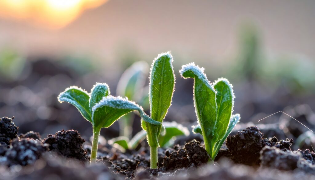
Plants Are Already Growing
Part of what makes spring frosts so damaging is timing. By March and April, many plants have broken dormancy and begun active growth. Leaves have emerged, flowers have bloomed, and new growth is tender and vulnerable.
Winter-dormant plants can tolerate quite cold temperatures because they’re not actively growing and have cellular protections in place. But once growth begins, those protections are abandoned. Active tissue contains more water, and cells are more fragile. Freezing causes ice crystals to form within plant tissues, rupturing cells and causing the blackened, wilted appearance of frost-damaged plants.
Different plants have different frost tolerances:
Hardy vegetables like peas, kale, and lettuce tolerate light frosts (down to 28-30°F) without damage.
Semi-hardy plants like potatoes and broccoli can handle brief exposure to 30-32°F but suffer damage below that.
Tender plants like tomatoes, peppers, and squash are damaged by any exposure below 32°F, and some sensitive varieties suffer at temperatures just above freezing.
Fruit trees are particularly vulnerable during bloom. Even brief exposure to temperatures in the mid-to-upper 20s can kill blossoms, destroying the year’s fruit crop.
The Last Frost Date Is a Gamble
Every region has an average “last frost date”—the date after which the probability of frost drops to some acceptable level (typically 10% or 20%). But this is only an average and a probability, not a guarantee.
Some years see last frosts weeks earlier than average. Other years experience freezes well past the typical date. The last frost date is a planning tool, not a promise.
In many regions, last frost dates are:
- Late March to early April in the Deep South
- Mid-to-late April in the Mid-Atlantic and lower Midwest
- Early to mid-May in the northern states
- Late May to early June in northern areas and higher elevations
But outlier events occur. Damaging frosts have hit southern regions in late April, and northern areas have seen June frosts in unusual years.
Gardeners who plant sensitive crops before the last frost date are gambling that the season will be typical or early. Some years they win and get an early harvest; other years they lose plants to late frosts and must replant.
Climate Change Affects Spring Frost Patterns
Warming temperatures are shifting average last frost dates earlier in many regions—sometimes by 1-2 weeks compared to historical averages. This sounds positive for gardeners and farmers, but it creates new risks:
Earlier spring warm-up causes plants to break dormancy sooner, exposing them to frost risk during a longer vulnerable period.
Greater temperature variability means larger swings between warm and cold, increasing the likelihood of damaging late freezes after significant warm periods.
Shifted patterns don’t eliminate risk. Even as average last frost moves earlier, outlier events still occur. A late-April freeze that was rare 50 years ago might still happen despite warming trends.
The result is more confusing and challenging conditions for agriculture and gardening—earlier growth but not necessarily earlier elimination of frost risk.
Protecting Against Late Frost
When frost threatens tender plants, several protection strategies work:
Covering plants with cloth, blankets, or commercial frost covers traps ground heat and prevents radiational cooling of plant surfaces. This works well for radiation frost but is less effective against advection frost (true cold air masses).
Watering before frost helps because moist soil holds and releases more heat than dry soil. The water itself has thermal mass that moderates temperature.
Using heat sources like candles, heat lamps, or smudge pots can raise temperature in small areas by a few degrees—sometimes enough to prevent damage.
Removing covers in morning is crucial. Covers left on in sunlight can overheat plants. They’re only for overnight protection.
Strategic planting in areas that avoid frost pockets, near buildings that radiate heat, or on south-facing slopes that receive maximum sun reduces frost risk.
Delaying planting of tender crops until well past average last frost date is the most reliable protection, though it means a shorter growing season.
Spring Frost Is a Seasonal Risk
Late spring frosts are simply part of the climate in temperate regions. The transition from winter to summer isn’t smooth or linear—it involves advances and retreats, warm spells and cold snaps, until finally summer patterns establish dominance.
Understanding that frost can occur into May in many areas, that clear calm nights are particularly dangerous, and that official temperatures don’t tell the whole story for ground-level conditions helps manage expectations and protect vulnerable plants.
That frost on your windshield in mid-April isn’t abnormal or shocking—it’s spring in a temperate climate, where the battle between winter and summer plays out over months rather than flipping like a switch. The warmth will win eventually, but not without winter making a few final stands that catch optimistic gardeners and early-leafing plants by surprise.