That Eerie Color Means Something Real
If you’ve lived in the Midwest or Great Plains long enough, you’ve probably seen it: the sky takes on an unnatural greenish or yellowish cast in the hour before a violent thunderstorm or tornado. It’s unsettling in a way that’s hard to describe — not quite any color the sky normally produces, somehow both dark and luminous at the same time. People who see it often describe a visceral sense of wrongness, an instinctive recognition that the atmosphere is doing something unusual.
They’re right. The green sky is real, it’s caused by specific atmospheric optics, and while it doesn’t guarantee a tornado is coming, it does indicate the kind of severe thunderstorm environment in which tornadoes form. Understanding what produces it explains one of the most striking and genuinely useful visual signals the spring sky can offer.
The Sky’s Color Is a Mixing Problem
To understand why a severe thunderstorm sky can look green, it helps to understand why the sky is blue in the first place.
Sunlight contains all visible wavelengths — all the colors of the rainbow — mixed together into white light. When sunlight enters Earth’s atmosphere, it collides with gas molecules that scatter shorter wavelengths of light (blue and violet) more readily than longer wavelengths (red and orange). This preferential scattering of blue light in all directions is what makes the sky appear blue — you’re seeing blue light scattered toward your eyes from every direction above you.
The sky’s color at any given moment is the result of which wavelengths of light are reaching your eyes after passing through and scattering off whatever is in the atmosphere between you and the sun. Change what’s in the atmosphere, and you change the color.
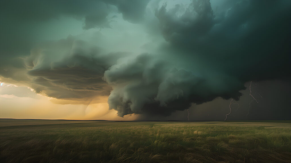
What a Supercell Thunderstorm Adds to the Equation
A supercell thunderstorm — the organized, rotating type responsible for most significant tornadoes — is a massive atmospheric structure that can extend from near the ground to 50,000 feet or higher. Its upper portions contain enormous concentrations of ice crystals and large water droplets. Its base, the area directly beneath the storm, is dominated by heavy rain and hail.
Late afternoon is when supercells most commonly reach their peak intensity, and late afternoon light is already shifted toward the red and orange end of the spectrum — the same reason sunsets are red and orange. The sun is low in the western sky, its light traveling through a longer path of atmosphere before reaching you, with blue wavelengths scattered away and redder wavelengths surviving.
Now add the supercell. The reddish-orange light of late afternoon sun illuminates the massive ice and water content of the storm’s interior. Ice crystals and large water droplets preferentially absorb red wavelengths of light while scattering blue and green. The transmitted light — what reaches your eyes after passing through the storm — has had its red component absorbed and its blue-green component preserved.
Red light plus blue-green light produces the greenish, sickly cast that severe storm observers recognize. It’s essentially the atmospheric equivalent of mixing paint: the warm tones of late afternoon light combined with the blue-green transmission properties of a water- and ice-laden storm interior produce a color the sky doesn’t normally show.
Why It’s Most Visible in the Midwest
The green sky phenomenon is observed most reliably in the central United States for reasons that go beyond the prevalence of severe weather there. The flat terrain of the Great Plains and Midwest allows unobstructed views of storm interiors from great distances. In mountainous or heavily forested regions, terrain and tree cover block the long sight lines required to see the storm’s full illuminated interior against a background sky.
The timing matters too. The Great Plains severe weather peak occurs in late afternoon and early evening — exactly when the sun’s angle produces the most red-shifted light that creates the most dramatic color contrast with the storm’s blue-green transmission. A storm producing the same optical properties at noon, with the sun high overhead and its light less red-shifted, would not produce the same green cast.
Does Green Mean Tornado?
The honest answer is: not necessarily, but it means you should pay close attention.
A green sky indicates a storm that is large, tall, and contains exceptional amounts of large water droplets and ice — the characteristics of a mature supercell thunderstorm. Supercells are the storms most likely to produce tornadoes, large hail, and damaging winds. Seeing a green sky means you are near or under a storm system with the organization and intensity required for severe weather.
It does not mean a tornado is guaranteed or imminent. Many supercells produce no tornadoes. Many green-sky events are followed by nothing more than heavy rain and hail. The green color is a sign of storm type and intensity, not a direct indicator of a tornado on the ground.
What it should reliably trigger is a shift in your attention and readiness. Check your weather alerts if you haven’t already. Know where your shelter is. Watch how quickly conditions are changing around you. The green sky is the atmosphere telling you it has assembled something serious — whether that translates to a tornado depends on factors unfolding inside the storm that the sky’s color alone can’t tell you.
Other Unusual Sky Colors Before Severe Weather
The green sky is the most famous pre-storm color, but severe thunderstorms can produce other unusual sky colors that carry similar implications.
A yellow or orange sky before a storm follows similar optical mechanics — late afternoon red-shifted light interacting with storm content — but at angles and moisture levels that shift the mixture toward yellow rather than green. This is common in the hour or two before a storm arrives when the storm is still to the west and the late afternoon sun is illuminating it from behind you.
A deep purple or bruised-looking sky often indicates a storm with extremely high water content approaching at dusk or after sunset, when the remaining light is highly red-shifted. The purple cast comes from the same mixing of red ambient light with the blue-green transmission of the storm, at lower overall light levels that deepen the color.
A greenish-black sky — darker and more ominous than the classic green — often indicates a storm approaching at peak intensity, with the green cast overlaid on the general darkening caused by the storm blocking available light. This is the version most frequently described by tornado survivors and witnesses as the most alarming sky color they’ve seen.
Reading the Sky as a Safety Tool
None of this sky-reading replaces official warnings from the National Weather Service. Tornado warnings are issued based on radar and storm spotter reports, and they are the authoritative signal to take shelter immediately. Sky color is supplementary information — useful context, not a substitute for staying informed through official channels.
But the green sky is also a reminder that the atmosphere communicates in ways beyond the forecast app. Knowing what you’re seeing and what it means turns an alarming color change from a source of vague dread into actionable information. That’s not superstition — it’s the same observational meteorology that humans have been doing for as long as we’ve watched the sky, now explained by the physics of light and water and ice working together in the most powerful storms the spring atmosphere can produce.
When the sky turns green, look at your phone. Know where your basement is. The atmosphere has told you something worth listening to.