Rivers Rise Every Spring. Here’s Why It Happens—and Why Some Years Are Far Worse Than Others.
Walk past a river in late March or April and it looks different than it did in January. The water is higher, faster, murkier, and often carrying debris — branches, foam, sometimes ice chunks — that it wasn’t carrying a month ago. Across much of the United States, rivers reach their annual peak in spring, and flood watches and warnings become a routine part of the forecast in a way they aren’t in other seasons. This isn’t random. Spring flooding is the predictable result of several forces converging at the same time, and understanding what drives it explains why some springs produce minor nuisances while others produce historic disasters.
The Snowpack Is a Reservoir You Can’t See
Across the northern United States, the Great Plains, and the mountain West, winter deposits enormous quantities of water on the landscape — not as liquid, but locked in snow and ice. The snowpack that accumulates between November and February is essentially a slow-release reservoir, storing water that will eventually enter rivers and streams as temperatures rise.
In an average year, the gradual warming of spring melts the snowpack slowly enough that rivers can accommodate the increased flow without major flooding. Temperatures rise a few degrees at a time, melting proceeds at a manageable pace, and rivers run high but stay within their banks or rise only modestly above flood stage.
But several factors can transform a normal snowmelt season into a flooding event. A snowpack that is larger than average — built up by a winter with above-normal precipitation — contains more water than rivers can easily handle when it melts. A sudden warming spell after a cold, slow spring can release months of stored water in days rather than weeks. And the timing of snowmelt relative to spring rain is critical: snowmelt arriving at the same time as heavy spring rains doubles the water entering the watershed simultaneously.
The 1997 Red River flood that devastated Grand Forks, North Dakota and reached record levels was driven in large part by an exceptionally deep snowpack that melted rapidly following a late-season blizzard. The same river flooded catastrophically again in 2009 and 2011 — always in spring, always driven by the same convergence of stored snow and rapid melt.
Frozen and Saturated Ground Can’t Absorb Water
Under normal conditions, soil acts as a sponge, absorbing a significant fraction of rainfall and snowmelt before it runs off into streams. This infiltration slows the rate at which water reaches rivers and reduces flood peaks significantly. A landscape with healthy, unfrozen, unsaturated soil can absorb inches of precipitation before producing meaningful runoff.
Spring strips away both of those buffers simultaneously, and often completely.
Frozen ground — common across the northern tier of states well into March and sometimes April — is essentially impermeable. Water that falls on frozen soil or flows from melting snow has nowhere to go but the surface, running directly into streams and rivers without any infiltration delay. The entire snowmelt volume, rather than a fraction of it, reaches rivers rapidly.
Even where ground isn’t frozen, soil saturation from a wet winter and early spring eliminates the absorption buffer. Once soil reaches field capacity — the maximum amount of water it can hold — additional precipitation runs off at nearly 100 percent efficiency. The landscape becomes a funnel rather than a sponge, routing every drop of rain directly toward waterways.
This is why antecedent moisture conditions — the accumulated wetness of the weeks and months before a flood event — are often more important than the precipitation that triggers the flooding itself. A single heavy rainstorm on dry summer soil might cause minimal flooding. The same storm on saturated spring soil can overwhelm rivers within hours.
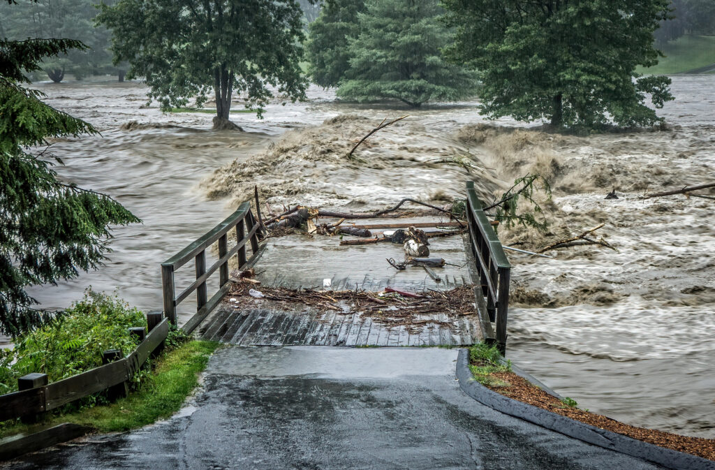
How Rivers Become Overwhelmed
A river’s capacity to carry water is determined by its channel dimensions and the speed at which water flows through it. In normal conditions, a river handles its typical volume within its banks. Flooding begins when inflow — from rain, snowmelt, and tributary streams — exceeds the river’s channel capacity and water spills over the banks into the surrounding floodplain.
The challenge in spring is that all of a river’s tributaries are experiencing the same conditions simultaneously. Every smaller stream and creek feeding into a main river channel is running high, delivering their individual contributions to the same downstream point at the same time. This convergence amplifies flood peaks far beyond what any single tributary could produce alone.
The timing of tributary contributions matters enormously. If tributaries in different parts of a watershed peak at different times, their crests pass through the main channel sequentially and the peak flow is manageable. But when a widespread event — a regional warm spell, a multi-day rain system — causes all tributaries to peak simultaneously, those contributions stack on top of each other. The resulting flood crest can be dramatically higher than models predict from any single part of the watershed.
River forecasters spend considerable effort tracking tributary timing for exactly this reason. Knowing whether the upstream branches of a major river will crest before, during, or after the downstream branches determines whether the main stem flood is moderate or severe.
Ice Jams: When Frozen Rivers Cause Sudden Flooding
Spring brings one flooding mechanism with no summer equivalent: the ice jam. As temperatures warm, river ice begins to break up, fracturing into chunks that float downstream. Where the river bends, narrows, or meets an obstacle, these ice chunks pile up and create a dam — an ice jam — that can back water up significantly in minutes.
Ice jam floods are among the most dangerous flooding events because they happen with almost no warning. A river can be well within its banks and rise to flood stage in less than an hour when a jam forms upstream. When a jam breaks — also with little warning — the sudden release of backed-up water sends a surge downstream that can exceed the original ice jam flood level.
Communities along rivers in northern states and Canada face ice jam risk every spring during breakup season. The Red River, the Connecticut River, the Mohawk, and dozens of other rivers in cold-climate regions produce ice jam events of varying severity most years. Forecasters monitor breakup conditions closely, but the unpredictability of jam formation and release makes ice jam flooding particularly challenging to warn for.
Flash Flooding: Spring Rain on Unready Ground
While snowmelt and ice jam flooding tend to develop over hours to days, spring also delivers the most dangerous rapid-onset flooding: flash floods from intense thunderstorms falling on saturated soil.
Flash floods are defined by their speed — rising water that goes from normal to dangerous in six hours or less. They occur when rainfall intensity exceeds the rate at which water can drain from an area, either because the storm is extremely intense or because the ground is already saturated and can absorb nothing additional.
Spring thunderstorms, particularly in April and May, can produce rainfall rates of one to three inches per hour — rates that would overwhelm drainage systems even on dry ground. On the saturated soils of mid-spring, even moderate rainfall totals can trigger flash flooding in low-lying areas, creek valleys, and urban environments where pavement prevents any infiltration.
Flash floods kill more people in the United States each year than any other weather hazard, including tornadoes and hurricanes. The majority of those deaths occur in spring, and a disproportionate number involve vehicles — people attempting to drive through flooded roads who underestimate the depth and current of moving water. Six inches of fast-moving water can knock a person down. Two feet can sweep away most passenger vehicles. The advice to turn around, don’t drown is not a suggestion — it reflects the actual physics of water and vehicle buoyancy.
Reading the Signs Before It Happens
Modern river flood forecasting has improved dramatically over the past two decades. The National Weather Service issues river forecasts for hundreds of gauging stations across the country, projecting expected crest heights and timing days in advance. Flood watches indicate that conditions are favorable for flooding to develop. Flood warnings mean flooding is occurring or imminent.
Monitoring these forecasts in spring — particularly if you live near a river, stream, or low-lying area — is as important as checking temperature and precipitation. A river that is currently below flood stage can rise quickly when upstream conditions change, and the forecast will often show that rise coming well before the water arrives.
Understanding why rivers flood in spring puts those forecasts in context. When you see a forecast for heavy rain on top of a saturated watershed with a large snowpack, you’re looking at the conditions that produced every major spring flood in American history — not a random event, but a predictable convergence of forces that the atmosphere assembles, in varying degrees, every single year.