Understanding the Specific Temperature Profiles That Turn Precipitation into Destructive Ice
Ask people to name winter’s worst weather and many will say blizzards—dramatic snowstorms with high winds and heavy accumulation. But meteorologists and emergency managers often fear ice storms more. A severe ice storm can cripple entire regions for weeks, snapping power lines, toppling trees, making roads impassable, and causing damage that takes months to repair. Unlike snow which falls reliably when temperatures are cold enough, ice storms require an extremely specific atmospheric temperature profile that doesn’t occur every winter. Understanding why some winters bring devastating ice storms while others see none reveals the delicate balance of temperature layers that must align to create freezing rain, and why slight changes in storm track or temperature can mean the difference between manageable snow and catastrophic ice.
The Precise Temperature Profile Required
Freezing rain forms only under very specific atmospheric conditions:
A layer of above-freezing air aloft (typically between 3,000 and 10,000 feet elevation) must exist where temperatures are above 32°F—warm enough to melt falling snow into liquid raindrops.
Below this warm layer, a shallow layer of below-freezing air at the surface (typically 1,000-3,000 feet thick) must exist where temperatures are below 32°F.
The surface cold layer must be relatively shallow and not extremely cold—ideally between 26°F and 32°F at ground level. If it’s too thick or too cold, raindrops refreeze into sleet before reaching the ground.
The warm layer must be warm enough (generally above 34-36°F) to completely melt snow into rain, not just partially melt it.
This “warm over cold” temperature inversion is the exact opposite of the normal atmospheric profile where temperature decreases with altitude. Creating this inversion requires specific weather patterns.
When all elements align: Snow falls from clouds aloft, melts completely in the warm layer, falls as liquid rain through the surface cold layer, and freezes on contact with surfaces at or below 32°F—creating the smooth, clear ice coating called glaze that defines an ice storm.
Why This Setup Is Uncommon
The precise temperature profile needed for freezing rain doesn’t occur frequently:
Normal winter conditions have cold air throughout the atmospheric column—no warm layer aloft—producing regular snow.
Typical warming trends bring warm air to the surface first, changing precipitation from snow to rain, not creating the warm-aloft-cold-below inversion.
The atmospheric temperature structure must be just right—a few degrees different in any layer changes freezing rain to snow or regular rain.
Only specific weather patterns create the necessary inversion, primarily frontal boundaries and storm tracks that bring warm air aloft while trapping cold air at the surface.
This specificity explains why some winters have multiple ice storms while others have none, and why ice storms often affect narrow geographic bands where temperature profiles are perfect while nearby areas get snow or rain.
Storm Tracks That Favor Ice Storms
Certain storm trajectories create ideal ice storm conditions:
Low-pressure systems tracking from the southern Plains northeast toward the Great Lakes or Ohio Valley often generate the warm-over-cold setup along their northwestern edge.
Warm air advection aloft from the south associated with these storms creates the above-freezing layer at mid-levels.
Cold air damming on the eastern side of the Appalachian Mountains traps cold surface air even as warm air moves overhead, creating prolonged freezing rain events along the Mid-Atlantic states.
The boundary zone between retreating Arctic air and advancing warm air from the Gulf of Mexico or Atlantic creates the temperature layering needed for freezing rain.
These patterns are most common from December through February when temperature contrasts are strongest and storm tracks frequently bring southern moisture into regions with Arctic air in place.
Geographic Patterns and Ice Storm Alley
Ice storms occur most frequently in specific regions:
A corridor from Texas and Oklahoma northeast through Arkansas, Tennessee, Kentucky, West Virginia, and into the Mid-Atlantic states experiences frequent ice storms—sometimes called “ice storm alley.”
This region sits where Gulf moisture commonly interacts with Arctic air, and where Appalachian topography enhances cold air trapping.
The southern Plains see ice storms when warm air overruns Arctic cold trapped at the surface.
The Pacific Northwest experiences ice storms from different mechanisms—cold air funneling through the Columbia River Gorge meeting Pacific moisture creates freezing rain in specific locations.
New England gets ice storms occasionally but less frequently than the Mid-Atlantic because storm tracks typically bring colder temperatures that produce snow instead.
The Great Lakes region sees more snow than ice because storm tracks typically keep the entire atmospheric column cold enough for snow.
Why Some Winters Are “Ice Years”
Certain large-scale atmospheric patterns favor ice storm development:
El Niño winters often bring more frequent southern storm tracks and increased moisture, raising ice storm probability in susceptible regions.
La Niña winters typically produce different storm tracks that may reduce ice storm frequency in some areas while increasing it in others.
The position and strength of the polar jet stream influences whether warm air can surge northward aloft while cold air remains trapped at the surface.
Persistent high pressure over eastern Canada can lock cold air in place for extended periods, setting up conditions where multiple storms track through with warm air aloft and create repeated ice events.
Temperature patterns that favor Arctic outbreaks followed by quick warm-ups create the oscillating conditions where inversions develop.
Some winters see these patterns repeat multiple times, creating clusters of ice storms. Other winters see storm tracks that consistently produce all snow or all rain, avoiding the narrow ice-producing temperature window.
Duration Determines Damage Severity
The length of freezing rain events determines ice accumulation:
Brief freezing rain (1-3 hours) glazes surfaces with minimal ice—perhaps 1/8 inch—creating hazardous conditions but limited structural damage.
Extended freezing rain (6-12 hours) accumulates 1/4 to 1/2 inch of ice, creating dangerous weight loading on trees and power lines. Significant damage begins.
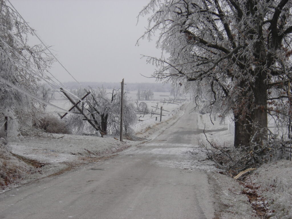
Major ice storms (12+ hours) can accumulate 1/2 inch to over 1 inch of ice, creating catastrophic conditions. Trees snap under weight, power systems fail completely, and recovery takes weeks.
The 1998 ice storm in Quebec and northern New England lasted days, accumulating 3-4 inches of ice in some locations—one of the most destructive ice storms in North American history.
Duration depends on how long the temperature inversion persists—how slowly the storm moves, how long the warm and cold layers maintain their positions.
Forecasting Challenges
Predicting ice storms is notoriously difficult:
Models must precisely predict the temperature profile thousands of feet up—small errors dramatically change whether precipitation falls as freezing rain, sleet, or snow.
The critical zone between freezing rain and other precipitation types is often just 25-50 miles wide. Models can be off by that distance even when generally accurate about storm position.
Temperature profiles can change during storms as different air masses surge or retreat, causing precipitation type to transition multiple times.
Forecasters must predict not just whether freezing rain will occur but how long it will last—the difference between a nuisance and a catastrophe.
Ice storm warnings are issued when confidence is high that damaging ice will accumulate, but exact amounts and durations remain uncertain until events unfold.
The Transition to and from Ice
Ice storms rarely occur in isolation—they’re usually part of a larger event:
Many ice storms begin as snow when the surface is coldest, transition to freezing rain as the warm layer aloft strengthens, then may end as plain rain if warm air reaches the surface.
Or the reverse: Rain begins, transitions to freezing rain as surface air cools, then changes to sleet or snow as the warm layer aloft collapses.
The transition zone between precipitation types moves geographically as the storm evolves. Areas may experience multiple precipitation types as boundaries shift.
Predicting these transitions is critical for preparation—knowing whether conditions will worsen into ice or improve to snow/rain affects emergency response decisions.
Why Ice Storms Are So Destructive
Ice accumulation creates unique hazards:
Weight is enormous. A 1/2 inch ice coating can add 500 pounds to a single power line span. Trees and structures experience similar loading.
Ice bonds to everything it contacts, making it difficult to remove and causing it to accumulate in problematic ways on structures not designed for such loads.
The destruction is widespread. Unlike tornadoes or floods which affect corridors, ice storms coat every surface across entire regions simultaneously.
Power restoration takes weeks because damage is so extensive and because ice must melt or be removed before repairs are even possible in many cases.
Travel becomes impossible. Ice-covered roads remain treacherous for days, and accumulation on vehicles makes them unusable.
Tree damage is permanent. Ice-split trees don’t recover, changing landscapes for years or decades.
Climate Change and Ice Storm Frequency
How warming affects ice storms is complex:
Warming might reduce ice storms in some regions by pushing temperatures high enough that winter precipitation falls as rain rather than requiring the precise warm-over-cold setup.
Or warming might increase ice storms in other regions by creating more frequent temperature oscillations between Arctic air and warm air, generating the inversions that create freezing rain.
The geographic zone susceptible to ice storms may shift northward as climate warms, affecting different regions.
Extreme variability in winter temperatures—a consequence of disturbed Arctic patterns—may create conditions favoring ice storms more frequently in some areas.
Research is ongoing and results vary by region. Some areas show increasing ice storm frequency, others decreasing, others no clear trend.
Preparing for Ice Storm Seasons
In ice-prone regions:
Monitor forecasts carefully when winter storms approach, paying attention to temperature profiles and precipitation type predictions.
Ice storm warnings are serious—they indicate conditions expected to create damaging accumulation requiring immediate preparation.
Prepare for extended power outages: Flashlights, batteries, food, water, alternate heating, full fuel tanks, charged devices.
Stay inside during ice storms. Falling ice-laden branches are extremely dangerous.
Avoid driving on ice-covered roads. Contrary to popular belief, experience and skill don’t overcome physics—ice provides almost zero traction.
Know that recovery takes time. Prepare mentally and practically for potentially weeks without power if severe ice accumulates.
A Narrow Window of Destruction
Ice storms represent one of winter’s most destructive weather phenomena precisely because they require such specific conditions. The atmospheric temperature profile must hit a narrow target—warm enough aloft to melt snow, cold enough at surface to refreeze rain on contact, with layers positioned just right to maximize ice accumulation rather than producing sleet or snow.
When winters align patterns that repeatedly create these conditions—whether through persistent high pressure systems, favorable jet stream configurations, or climate patterns like El Niño—ice storms can occur multiple times, devastating the same regions repeatedly. Other winters avoid these patterns entirely, producing normal snow or rain but never hitting that narrow freezing rain window.
Understanding that ice storms aren’t just “winter weather” but specific events requiring precise atmospheric conditions helps explain why forecasting them is so challenging, why they affect narrow geographic bands so dramatically differently, and why some winters bring ice disaster while others pass with no significant freezing rain at all. It’s a reminder that winter precipitation exists on a spectrum, and the most destructive type sits in the narrowest, most specific zone—where temperature profiles align just precisely enough to turn frozen precipitation into liquid, then immediately back to ice upon contact, building glazed coatings that transform landscapes from functional to paralyzed in a matter of hours.