A Storm That Crossed Three States and Changed Everything
On the afternoon of March 18, 1925, a tornado touched down in southeastern Missouri and began moving northeast. Over the next three and a half hours, it traveled 219 miles across Missouri, Illinois, and Indiana — the longest continuous tornado track ever recorded in the United States. When it finally dissipated near Princeton, Indiana, it had killed 695 people, injured more than 2,000, and destroyed entire towns so completely that some were never fully rebuilt.
The Tri-State Tornado remains the deadliest tornado in American history by a wide margin. The next deadliest — the Natchez Tornado of 1840 — killed 317 people. No tornado since has come close to the Tri-State’s death toll, and a century of improved forecasting, warning systems, and construction standards makes it almost certain none ever will. Understanding what made it so catastrophic — and what was different about that March afternoon — reveals both how far tornado science and warning technology have advanced and how much the atmosphere is still capable of when conditions align.
What Made It So Deadly
Several factors combined to make the Tri-State Tornado a uniquely catastrophic event, and most of them had nothing to do with the tornado being unusually large or powerful — though it was both.
The most important factor was the complete absence of any warning system. In 1925, the United States Weather Bureau did not issue tornado warnings. The word “tornado” was officially prohibited from Weather Bureau forecasts on the theory that it would cause unnecessary panic. Residents of the towns in the tornado’s path had no advance notice whatsoever. People in Murphysboro, Illinois — where 234 people died, making it the single deadliest location — heard nothing unusual until the tornado was upon them.
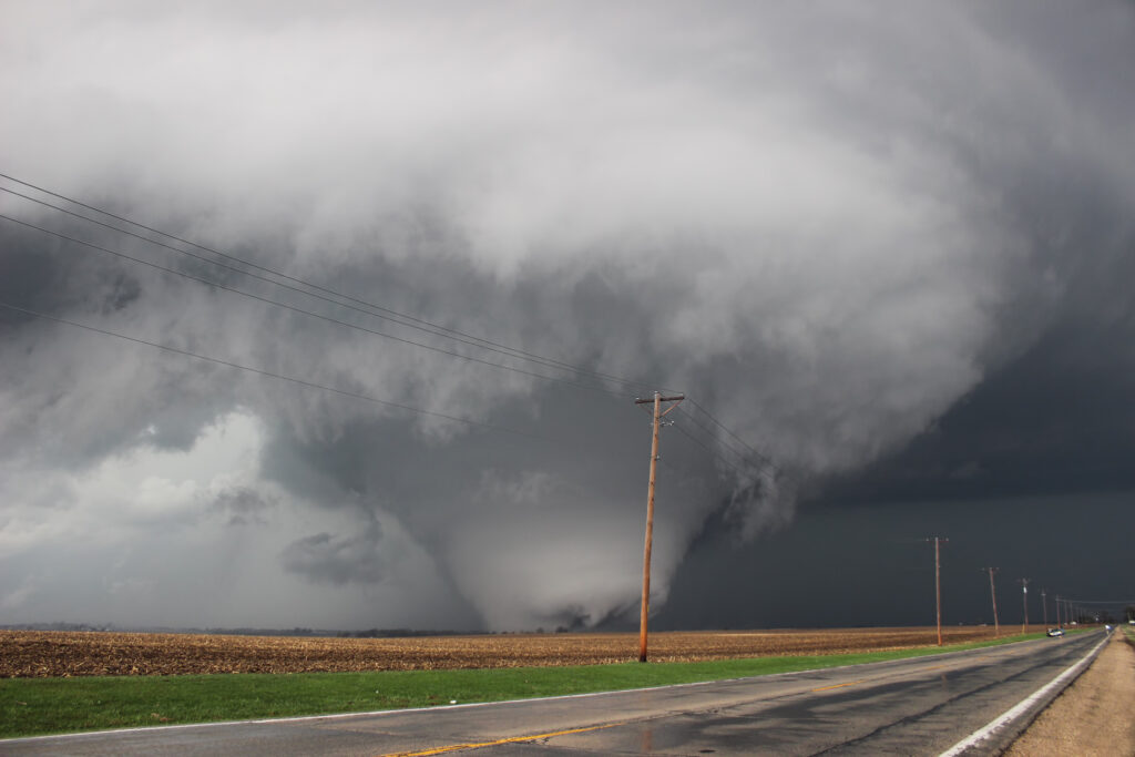
The tornado also moved with exceptional speed. Most tornadoes travel at 20 to 40 miles per hour. The Tri-State moved at an average of 62 miles per hour, with some segments tracked at over 70 miles per hour. At that speed, even the few seconds of visual warning a fast-moving observer might have had were not enough to reach shelter. People in the tornado’s path had almost no time to react.
The path also tracked directly through densely populated mining and farming communities in some of the most heavily settled rural areas of the Midwest. Towns like Gorham, Murphysboro, De Soto, and West Frankfort in Illinois lay directly in the track. De Soto’s school was struck while students were inside — 33 children were killed when the building collapsed.
Finally, construction standards of the era offered almost no protection. Most homes in the tornado’s path were wood-frame structures with no basements, built to no particular wind resistance standard. Against a tornado of this intensity, they offered their occupants nothing.
The Track Itself Was Extraordinary
The 219-mile continuous track is itself a meteorological puzzle that researchers have examined for a century. Most tornadoes last minutes and travel a few miles. Long-track tornadoes — those exceeding 25 miles — are rare and remarkable. A tornado maintaining continuous contact with the ground for 219 miles across three states is so anomalous that some researchers have periodically argued it must have been a series of tornadoes rather than one continuous storm.
The current meteorological consensus, supported by damage surveys and historical records, is that it was indeed a single continuous tornado — a particularly violent supercell thunderstorm that maintained an unusually stable and persistent mesocyclone across a favorable atmospheric environment for hours. The conditions on March 18, 1925, were exceptional: a powerful low-pressure system over Kansas driving warm, moist Gulf air northward into a cold airmass, with extreme wind shear provided by strong jet stream winds aloft. The atmosphere was as primed for a violent, long-lived supercell as it’s possible to be.
The tornado’s width — estimated at up to a mile across at its widest — was also extreme. At these dimensions, it was less a discrete funnel than a massive, churning mass of violent wind that encompassed entire towns simultaneously rather than cutting through them.
The Towns That Were Erased
The human geography of the Tri-State Tornado’s path reads as a catalog of communities that were simply removed from the landscape in a matter of seconds.
Gorham, Illinois, a town of 500 people, was almost entirely destroyed. Murphysboro lost more than 800 buildings and a quarter of its population killed or injured. De Soto, where the school collapse killed 33 children, lost most of its structures. West Frankfort, a coal mining town, was struck as miners were changing shifts — the timing meant large numbers of men were on the surface rather than underground, and the death toll there reached 148.
In Indiana, the towns of Griffin and Owensville were devastated before the tornado finally weakened and lifted near Princeton. The damage path was so consistent and complete that the National Weather Service has called the Tri-State Tornado’s path one of the most thoroughly documented destruction corridors in American weather history.
Recovery in the hardest-hit communities took years. Some neighborhoods were rebuilt; others were permanently abandoned. The mining towns that had been devastated were already in decline before the tornado, and the destruction accelerated that trajectory. Several communities never recovered their pre-storm populations.
What Changed Because of It
The Tri-State Tornado was a pivotal event in the history of American meteorology, though the changes it prompted came slowly. The Weather Bureau’s prohibition on the word “tornado” in forecasts persisted for decades after 1925, not being formally lifted until 1938, and operational tornado forecasting didn’t develop meaningfully until after World War II, when radar technology and military meteorological research created the tools to make it possible.
The first successful tornado forecast — a prediction issued before a tornado struck rather than after — wasn’t made until 1948, when Air Force meteorologists at Tinker Air Force Base in Oklahoma correctly predicted a tornado that struck the base. That forecast, and the system of tornado watches and warnings it eventually spawned, is the direct ancestor of the National Weather Service severe weather warning system that exists today.
The Tri-State Tornado also contributed to the long-term research interest in supercell thunderstorms and long-track tornadoes that eventually produced the scientific understanding of tornado formation we have today. The questions it raised — how a tornado could maintain itself for 219 miles, what atmospheric conditions supported such a long-lived storm — drove decades of meteorological research.
The Tornado Season It Represents
March 18, 1925 was a day in early spring — nearly the same point in the calendar as the present — with the atmospheric conditions that characterize the beginning of tornado season: powerful jet stream, cold air aloft, warm Gulf moisture surging north, extreme wind shear. Those conditions assemble themselves every spring across the central United States. The Tri-State Tornado represents what they’re capable of producing at their most extreme.
The differences between that March afternoon and a similar severe weather day today are not atmospheric — the same ingredients exist and will always exist in spring. The differences are in warning time, shelter options, and the ability of meteorologists to see a supercell organizing hours before it produces a tornado. A storm with the Tri-State’s characteristics forming today would trigger watches and warnings hours in advance, activate emergency alerts on millions of phones, and send residents to basements and storm shelters with time to spare.
That gap between 1925 and today — built through a century of meteorological science, radar technology, and emergency management infrastructure — is measured in the lives that would not be lost. The Tri-State Tornado killed 695 people. An equivalent storm today would not.