Fifty-Three Years Ago Tonight
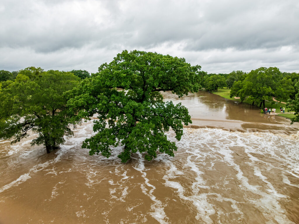
On the evening of June 9, 1972, a cluster of thunderstorms stalled over the eastern Black Hills of South Dakota and proceeded to drop an extraordinary amount of rain — up to 15 inches in six hours in some locations — over the steep terrain above Rapid City. The water that fell on those forested hillsides had nowhere to go but down, and it came down all at once, funneling into Rapid Creek and the smaller streams that fed it, building into a wall of water that reached 15 feet above normal stream level before it crashed through the city below.
In a single night, 238 people died. More than 3,000 were injured. Nearly 1,300 homes and 5,000 vehicles were destroyed. The flood carved a path through Rapid City that erased entire neighborhoods, deposited cars in trees, and left a debris field that took months to clear.
The Rapid City Flood of June 9, 1972 remains the deadliest flash flood in the history of the northern Great Plains, and one of the most consequential weather disasters in terms of what it changed about how the United States monitors and warns for flash flooding. The warning system that exists today — the network of stream gauges, rainfall sensors, and National Weather Service flash flood products — was substantially shaped by the failures of that night.
The Terrain and the Storm
The Black Hills of South Dakota rise abruptly from the surrounding plains, reaching elevations above 7,000 feet within a short horizontal distance from Rapid City, which sits at roughly 3,200 feet at the base of the hills. This dramatic relief creates a specific meteorological vulnerability: storms that develop over or drift onto the high terrain can produce extreme rainfall rates over a short area, and the steep slopes funnel that water rapidly into narrow valleys and stream channels below.
The storms that produced the 1972 flood were a cluster of slow-moving thunderstorms that developed over the Black Hills in the early evening and essentially parked over the same terrain for hours. Meteorologists describe this as training — successive storm cells moving over the same area like boxcars on a train, each depositing its rainfall on ground already saturated by the cells that preceded it.
By the time the storms finally moved off the terrain, they had deposited between 10 and 15 inches of rain in six hours over portions of the watershed above Rapid City — a rainfall total that might be considered extraordinary over a year in some parts of the country. Over steep, largely impermeable terrain — granite and other hard rock underlie much of the Black Hills — this water had almost no opportunity to infiltrate. It ran off almost immediately into Rapid Creek and its tributaries.
The resulting flood surge traveled downstream at speeds estimated between 15 and 20 miles per hour, reaching Rapid City with essentially no warning. The first indication that something catastrophic was happening upstream came when people in the city heard the roar of the approaching water — by which point there were minutes, not hours, to respond.
What People Were Doing That Night
June 9, 1972 was a Friday evening in early summer. Rapid City was at the beginning of its tourist season — the Black Hills, home to Mount Rushmore and Custer State Park, draw significant summer tourism. Canyon Lake Park, a recreational area along Rapid Creek within the city, had been a popular destination through the day. The campgrounds upstream were occupied. The neighborhoods along Rapid Creek — modest residential areas developed in the creek’s floodplain in the decades after World War II — were full of people going about their Friday evening routines.
The National Weather Service had issued flash flood watches and warnings for the region, but the communication of those warnings to the public in 1972 was limited by the technology and infrastructure of the time. Weather radio broadcasts were available but required a dedicated receiver to hear. Television and radio broadcasts carried warnings, but many people were not watching or listening at the critical moment. There was no mechanism analogous to the Wireless Emergency Alert system that would push a notification directly to every phone in a warning area — that technology was 40 years away.
Many people died because they had no idea the flood was coming until it arrived. Others received warnings but underestimated the threat — a calculation not unlike the survivorship-based underestimation covered in the hurricane myths piece, but compressed into a single evening rather than a history of storms. Canyon Lake Dam, a small earthen dam in the city, failed as flood levels rose, releasing an additional surge that contributed to the chaos of the night.
The Scale of Destruction
The flood’s path through Rapid City was defined by Rapid Creek’s channel and the floodplain that had been developed on either side of it. The creek, normally a modest stream, carried a flood crest that overwhelmed every bridge in its path and deposited debris — entire houses, vehicles, and trees — across a broad swath of the city.
Canyon Lake, the reservoir behind the failed dam, drained entirely, adding its contents to the already extraordinary flow. Neighborhoods immediately downstream of the dam were inundated under several feet of water within minutes of the failure, giving residents essentially no time to respond.
The National Guard was activated within hours, but the scale and speed of the disaster overwhelmed initial response capacity. Rescue operations continued through the night and into the following days as floodwaters receded and the extent of the damage became apparent. Bodies were recovered from the debris field — from beneath collapsed structures, from trees where the flood had deposited them, from the gravel bars and debris jams downstream — over a period of weeks.
The final death toll of 238 was almost certainly an undercount of immediate deaths, as the exact population in the flood zone on that specific evening — including tourists and campers — was never precisely established.
What Changed Because of It
The Rapid City Flood produced changes in flash flood warning infrastructure that were as significant in their domain as the post-tornado changes produced by the Palm Sunday Outbreak and the 1985 Pennsylvania outbreak.
Stream gauge networks expanded dramatically. One of the primary reasons the 1972 flood killed so many people was the absence of real-time stream monitoring in the Black Hills that would have detected the rising waters upstream and provided warning time to downstream communities. In the years following the flood, the USGS and National Weather Service dramatically expanded the network of automated stream gauges that continuously monitor water levels and transmit data in real time. Today, the network covers tens of thousands of stream and river locations across the country — a monitoring capability that simply didn’t exist in 1972.
Flash flood warning procedures were reformed. The 1972 flood revealed that flash flood watches and warnings were not reaching people who needed them, particularly in recreational settings — campgrounds, parks, and river corridors where people had no access to broadcast media. New procedures for notifying campground operators, park rangers, and other gatekeepers to recreational areas were developed. The concept of targeting warnings to specific populations at specific risk — rather than issuing broad geographic warnings and assuming they would reach everyone — grew from the 1972 experience.
Floodplain management in Rapid City was transformed. In the aftermath of the flood, Rapid City made the decision to not rebuild residential and commercial structures in the Rapid Creek floodplain — a policy that was among the most aggressive floodplain management decisions in American municipal history at the time. The land along the flood path was converted to greenway, parks, and golf courses — open space that has no occupied structures to be damaged in future floods. This decision, controversial at the time, has been repeatedly validated as subsequent flood events have occurred without the casualties that would have resulted if the floodplain had been rebuilt to pre-1972 density.
Doppler radar’s value for flash flood forecasting was reinforced. The 1972 flood occurred before the NEXRAD Doppler radar network — but the ability of advanced radar to estimate rainfall rates over specific terrain and trigger automated flash flood products was developed and deployed in subsequent decades partly in response to events like the 1972 flood. Modern dual-polarization radar can estimate rainfall accumulation with sufficient accuracy to support automated flash flood alerts when rainfall thresholds are exceeded over specific watersheds.
Flash Floods Today: The Warning Challenge That Persists
Despite 53 years of infrastructure development since the Rapid City Flood, flash floods remain the deadliest weather hazard per event in the United States, killing more people annually than tornadoes in most years. The warning challenge that killed 238 people in Rapid City has not been fully solved — it has been substantially improved but not eliminated.
The fundamental difficulty is speed. Flash floods, by definition, develop faster than other flood types — the National Weather Service defines a flash flood as a rapid-onset flood event reaching its crest within six hours of the causative rainfall. In extreme terrain-focused events like the 1972 flood, the time from rainfall onset to catastrophic flooding can be measured in hours. Warning systems that depend on detecting a problem, communicating it through official channels, disseminating it to the affected population, and allowing time for protective action must compress all of those steps into the available window — which in the most extreme events is very short.
The “Turn Around, Don’t Drown” public awareness campaign — now a standard element of summer flash flood safety messaging — exists because vehicle-related drowning in flooded roadways is consistently the most common cause of flash flood fatalities, and it occurs when people drive into water of unknown depth that appears manageable. Six inches of moving water can knock a person down. Twelve inches can float a small car. Two feet of moving water will sweep away most vehicles. The physics are unambiguous and the outcome is predictable — yet the behavior persists because moving water in a familiar road context doesn’t trigger the visceral danger response that more dramatic weather hazards produce.
A City That Learned and Changed
Rapid City’s response to the 1972 flood — converting the floodplain to open space rather than rebuilding in it — stands as one of the more consequential land use decisions in American municipal history. It is also one of the least known outside of flood management and urban planning circles.
The greenway along Rapid Creek today is a pleasant park system that residents use for recreation, not a monument to the 238 people who died along its banks. But the absence of structures in that floodplain — the decision to let the creek have the land it occasionally claims — is itself the monument. Every subsequent flood event that has caused property damage and no deaths along Rapid Creek is the direct consequence of that decision.
It is a lesson that communities along flood-prone waterways continue to learn and relearn, sometimes after disasters of their own. The Rapid City Flood of June 9, 1972 was one of the more expensive teachers.