The Desert That Becomes a Thunderstorm Factory
Ask most Americans where monsoons occur and they’ll say India, Southeast Asia, or Africa — the dramatic seasonal rainfall systems that define tropical climates and fill reservoirs that entire populations depend on. What most don’t know is that North America has its own monsoon — a well-defined, seasonally recurring wind shift that transforms the desert Southwest from its driest period of the year into an active, sometimes violent thunderstorm season beginning in July and running through September.
The North American Monsoon, sometimes called the Arizona Monsoon or the Southwest Monsoon, is one of the most dramatic seasonal weather transitions on the continent. Phoenix, which may go four months without measurable rainfall in the spring, receives roughly half of its annual precipitation in the July through September monsoon window. Tucson receives nearly two-thirds of its annual rainfall during the monsoon. The desert that bakes in dry silence through May and June erupts into afternoon thunderstorms, flash floods, and dramatic dust storms — called haboobs — when the monsoon establishes itself.
Understanding how this transformation happens reveals the same atmospheric physics that drives monsoon systems globally, operating over a landscape with its own specific character.
What a Monsoon Actually Is
The word monsoon derives from the Arabic mawsim, meaning season — and a monsoon is precisely a seasonal wind shift, a predictable reversal of the prevailing wind direction that brings fundamentally different air masses and weather patterns to a region on a regular annual schedule.
All monsoons share the same basic mechanism: differential heating between land and ocean. Land heats and cools faster than ocean water, creating seasonal pressure differences that drive large-scale wind patterns. In summer, land heats more rapidly than the adjacent ocean, creating a low-pressure zone over the heated land surface. The relatively cooler, higher-pressure ocean air flows inland to fill this pressure deficit — and if the ocean air carries substantial moisture, it brings rain.
In winter, the reverse occurs. Land cools faster than the ocean, creating a high-pressure zone over the cold land that pushes air outward toward the warmer, lower-pressure ocean. Winter monsoon winds blow from land to sea and carry dry continental air rather than moist ocean air.
The Indian Monsoon — the most famous example — follows this pattern at continental scale: the massive Eurasian landmass heats intensely in summer, drawing moist air northward from the Indian Ocean and delivering extraordinary rainfall to South Asia. The North American Monsoon operates through the same physics at a smaller scale, driven by the heating of the desert Southwest and the elevated terrain of the Sierra Madre Occidental in northwestern Mexico.
The Specific Mechanism of the North American Monsoon
The North American Monsoon has several specific features that distinguish it from a simple land-sea breeze and make it a genuine seasonal circulation rather than just a local wind pattern.
Through spring and early summer, the prevailing wind flow over the desert Southwest is from the west and northwest — dry air descending from the Pacific that keeps the region in its characteristic hot, arid conditions. Spring and early summer are typically the driest period of the year across Arizona, New Mexico, and adjacent areas.
As summer advances and the desert surface heats to extreme temperatures — Tucson regularly reaches 110°F in June, Phoenix even higher — a thermal low-pressure center develops over the desert Southwest and the adjacent Sierra Madre of Mexico. This feature, called the Southwest Monsoon Trough, becomes established through late June and early July and begins drawing air from a different direction: from the south and southeast, off the Gulf of California and the Gulf of Mexico.
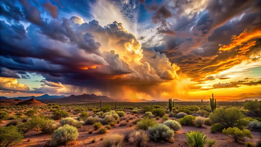
This wind shift — from dry westerly flow to moist southerly flow — is the monsoon onset. It typically arrives in southern Arizona and New Mexico in early July, progressing northward through the month. When the moisture-laden air from the Gulf of California flows northward over the superheated desert and encounters the elevated terrain of the sky islands — the mountain ranges that rise abruptly from the desert floor across southern Arizona and New Mexico — it is forced upward, cools, and condenses into the dramatic afternoon thunderstorms that define monsoon season.
What Monsoon Thunderstorms Look Like
Monsoon thunderstorms have a specific character that differs from both the severe spring thunderstorms of the Plains and the relatively gentle summer afternoon convective storms of the humid East.
They tend to develop rapidly in the early afternoon as surface heating combines with the moisture-laden air mass to produce extreme instability. The sky can go from clear and blazing hot at noon to dark and threatening by 2 p.m., with the first lightning by 3 p.m. and heavy rain by 4 p.m. The storms are typically shorter-lived than Plains supercells — lasting 30 to 90 minutes rather than several hours — but can produce extraordinary rainfall rates during their brief existence.
Rainfall rates of two to three inches per hour are not unusual in monsoon thunderstorms, and totals of one to two inches in less than an hour are common. Over the desert terrain — hardpacked soil, rocky hillsides, and arroyos (dry streambeds) that channel water efficiently — these rainfall rates produce flash flooding with remarkable speed. Desert flash floods are among the most dangerous flash flood events anywhere in the country: the water can arrive in a dry arroyo with no warning, carrying a wall of debris and moving at car-sweeping force, even when no rain is visible at the flood location. The rain that produced the flood may have fallen miles away over mountains that drained into the arroyo.
The “Turn Around, Don’t Drown” guidance that applies to all flash flood situations is particularly critical in the desert Southwest during monsoon season. More flash flood deaths occur in Arizona than in any other state in most years, and vehicle-related drownings in flooded washes are the predominant cause.
Haboobs: The Monsoon’s Dust Storms
One of the most visually striking phenomena associated with the North American Monsoon is the haboob — a massive dust storm generated by the outflow of a collapsing thunderstorm. Haboob is an Arabic word borrowed into English through meteorological usage, reflecting that the phenomenon was first described systematically in Sudan, where it also occurs regularly.
When a monsoon thunderstorm produces heavy rain and strong downdrafts, the cold air descending from the storm’s interior rushes outward along the desert surface at speeds that can exceed 50 mph. This outflow wind picks up the loose, dry desert soil and carries it forward as a dense wall of dust that can be 3,000 to 5,000 feet tall and miles wide. Visibility within a haboob drops to near zero almost instantly — the change from clear air to total dust obscuration can happen in seconds.
Phoenix experiences some of the most dramatic haboobs in North America. The city’s location at the edge of the desert, surrounded by fine alluvial soil from dried riverbeds, provides abundant material for the outflow winds to mobilize. Phoenix haboobs have been photographed from aircraft and satellites, appearing as enormous dark walls consuming the city — images that regularly attract national attention when they occur.
Haboobs create driving hazards comparable to blizzard conditions, produce respiratory irritation from fine dust particles, and deposit layers of silt across everything outdoors. The appropriate response when a haboob approaches while driving is to pull off the road, turn off the engine and lights, and wait for it to pass — driving into reduced-visibility dust conditions is as dangerous as driving into blizzard whiteout.
Monsoon Variability: Why Some Years Are Wetter Than Others
Like all monsoon systems globally, the North American Monsoon varies significantly from year to year in timing, intensity, and geographic extent. Some monsoon seasons deliver well above normal rainfall, filling desert reservoirs and greening the landscape with unusual lushness. Others are frustratingly weak, with the moisture flow failing to establish or delivering rainfall well below normal.
Several large-scale climate patterns influence monsoon strength. The position and intensity of the subtropical high-pressure system over the Atlantic — the Bermuda High — affects the flow of Gulf of Mexico moisture into the Southwest. El Niño and La Niña influence monsoon variability, though the relationship is less direct than their influence on winter precipitation patterns in the same region. Sea surface temperatures in the Gulf of California directly affect the moisture available for the monsoon circulation.
The monsoon’s onset date — when the seasonal wind shift first establishes — is also variable, ranging from late June in early-onset years to late July in late-onset years. An early, strong monsoon onset can be the difference between a year of adequate rainfall and a year of drought continuation across a region that depends on the summer rains for a significant fraction of its annual water budget.
Why the Monsoon Matters Beyond the Southwest
The North American Monsoon’s significance extends beyond the desert Southwest in several ways that are less obvious than the immediate weather impacts.
The monsoon is a critical component of the water budget for a region that is home to tens of millions of people and some of the fastest-growing metropolitan areas in the country. Phoenix, Tucson, Albuquerque, El Paso, and Las Vegas all exist in a water-stressed landscape where monsoon rainfall is not merely a weather event but a component of water supply planning. Monsoon rainfall recharges aquifers, fills reservoirs, and maintains the desert ecosystem that defines the region’s character.
The monsoon also affects wildfire risk. The dry spring preceding monsoon onset — when vegetation is at its most dessicated and fire danger is extreme — transitions rapidly when monsoon moisture arrives. The greening of the desert that follows monsoon establishment reduces fire spread potential and effectively ends the most dangerous phase of the Southwest fire season. Years when the monsoon is late or weak extend the high fire danger period correspondingly.
For people in the interior West and Great Plains, the monsoon’s influence extends through its interaction with the broader summer weather pattern. Moisture that flows northward ahead of the monsoon circulation can reach the Four Corners region and southern Rockies, affecting weather patterns across a much larger area than the core monsoon region.
A Different Kind of Summer Storm Season
The North American Monsoon produces one of the most visually dramatic and ecologically significant seasonal transitions anywhere on the continent. The desert that seems inhospitable and static through spring reveals itself, when the monsoon arrives, as a landscape adapted to and dependent on this specific seasonal pattern — blooming almost overnight as moisture returns, filling with bird and insect life, producing the wildflower displays and green hillsides that the dry season gives no indication are coming.
The monsoon’s thunderstorms are real hazards, its flash floods are genuinely dangerous, and its haboobs are spectacular enough to stop traffic. But the arrival of the first monsoon storm after months of relentless dry heat is, in the desert Southwest, one of the most anticipated and celebrated weather events of the year. The smell of rain on hot desert soil — the petrichor discussed in the 4/27 piece — is nowhere more intense than in the desert after a two-inch monsoon downpour on ground that hasn’t seen rain in four months.