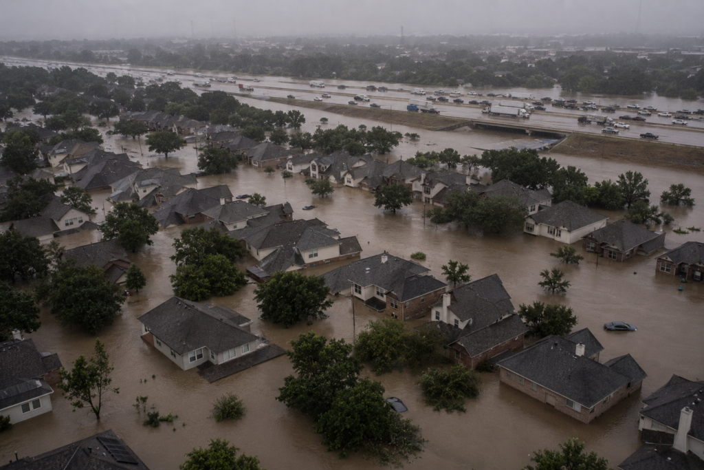
A Storm That Got More Dangerous After It Stopped Being a Hurricane
Hurricane Harvey made landfall near Rockport, Texas, on August 25, 2017, as a powerful Category 4 hurricane, and by conventional measures, the most dangerous part of the story should have ended within a day or two of landfall, as the storm weakened and its winds diminished. Instead, Harvey’s most catastrophic phase was just beginning. Over the following days, the storm stalled over the Houston metropolitan area and produced rainfall totals that redefined what meteorologists believed a tropical system could deliver to a single region.
A Storm That Simply Stopped Moving
The defining characteristic of Harvey’s flood disaster wasn’t its wind or its surge—it was its almost complete lack of forward motion after landfall. Instead of continuing inland and gradually weakening as most tropical systems do, Harvey stalled, trapped between two areas of high pressure that blocked it from moving in any consistent direction. For nearly four days, the storm essentially parked itself over southeastern Texas, repeatedly pulling moisture from the Gulf of Mexico and dumping it on the same region over and over.
This stalling behavior transformed Harvey from a wind-driven hurricane into what was functionally a stationary rainfall generator, delivering the kind of sustained, repeated rainfall that a storm moving at a normal forward speed would have spread across a much wider area and a much shorter timeframe.
Rainfall Totals That Broke Records
Parts of the Houston area received more than 60 inches of rain over the course of the event—a figure that exceeded the annual average rainfall for the region delivered in less than a week. This made Harvey the wettest tropical cyclone in U.S. recorded history, and the National Weather Service was forced to add new colors to its rainfall total maps because existing scales didn’t extend high enough to represent what parts of Texas had actually received.
The sheer volume overwhelmed every layer of the region’s flood infrastructure simultaneously: storm drains, bayous, and the reservoirs specifically built to manage flood risk all reached capacity at the same time, across the same days, leaving water with nowhere left to go except into homes, highways, and businesses across a metropolitan area of more than six million people.
A Flood Control System Built for a Different Kind of Storm
Houston’s flood infrastructure, including the Addicks and Barker reservoirs built specifically to protect downtown Houston from bayou flooding, had been designed based on historical rainfall patterns that didn’t anticipate an event of Harvey’s magnitude. When the reservoirs approached their design capacity, the Army Corps of Engineers made the difficult decision to release water in controlled amounts to prevent an uncontrolled dam failure—a decision that flooded homes downstream that had been built, in some cases with government permits, in areas engineers had designated as reservoir flood pools decades earlier but that had never actually flooded until Harvey.
This exposed a broader problem that extended well beyond any single storm: decades of unchecked development across the Houston region had paved over prairie land that once absorbed rainfall naturally, replacing it with impermeable surfaces that sent water directly into an already overwhelmed drainage system.
The Human Toll and the Recovery
Harvey caused an estimated $125 billion in damage, making it one of the costliest natural disasters in U.S. history, and it directly and indirectly caused 68 deaths in Texas, with many resulting from vehicles being swept into floodwaters or people becoming trapped in flooded homes. More than 30,000 people required emergency shelter, and over 300,000 structures sustained flood damage across the region.
The recovery exposed the scale of the challenge facing a major metropolitan area after a flood of this magnitude—hundreds of thousands of flood insurance claims, a housing market disrupted for years, and a rebuilding process complicated by the reality that many of the flooded structures had never been in an officially designated floodplain, meaning many homeowners lacked flood insurance entirely.
What Harvey Changed
In Harvey’s aftermath, Houston and Harris County pursued substantial changes to flood management policy, including updated floodplain maps that better reflect actual flood risk, stricter building codes requiring new construction to be elevated above updated flood risk thresholds, and significant investment in additional flood control infrastructure, including a long-discussed third reservoir intended to provide additional flood storage capacity for the western part of the metro area.
Harvey also became a pivotal case study in the growing body of climate attribution research, with subsequent analysis finding that the storm’s extreme rainfall was substantially more likely and more intense than it would have been in a cooler historical climate—research that has informed how meteorologists and engineers now think about designing infrastructure for future storms rather than relying solely on historical rainfall records.
A Storm That Redefined What “Worst Case” Meant
Harvey’s legacy is a reminder that a hurricane’s most dangerous phase doesn’t necessarily end when its winds weaken and its category rating drops. The storm that mattered most to millions of Houston-area residents wasn’t the Category 4 hurricane that made landfall—it was the stalled, weakening system that lingered for days afterward, delivering rainfall totals that no flood infrastructure in the country had been designed to handle.