The Eyes in the Sky That Watch Earth’s Weather 24/7
Every weather forecast you see begins with data gathered hundreds or thousands of miles above your head. Weather satellites orbit Earth constantly, capturing images and measurements that meteorologists use to track storms, predict temperature changes, and warn about dangerous conditions. Understanding how these satellites work reveals just how much technology goes into something as simple as checking tomorrow’s weather.
Two Types of Weather Satellites
Weather satellites fall into two main categories based on their orbits, and each serves different purposes:
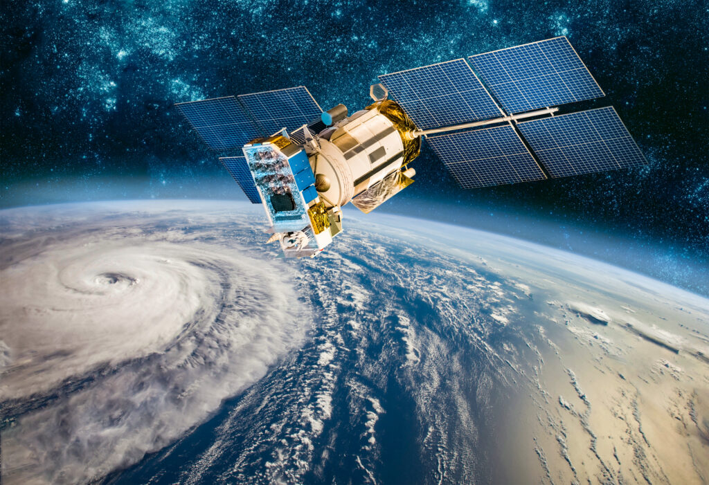
Geostationary satellites orbit at approximately 22,236 miles above the equator, moving at the same speed Earth rotates. This keeps them fixed over one spot on the planet, providing continuous observation of the same region. These satellites capture images every 5-15 minutes, allowing meteorologists to watch weather systems develop and move in near real-time.
The United States operates the GOES (Geostationary Operational Environmental Satellites) series positioned over the Atlantic and Pacific. Other nations operate similar satellites over their regions, creating a network that monitors most of Earth’s weather continuously.
Polar-orbiting satellites fly much lower—around 500-600 miles up—and circle Earth from pole to pole. As they orbit, Earth rotates beneath them, allowing these satellites to observe the entire planet’s surface over the course of a day. They pass over the same spot twice daily, providing detailed measurements of temperature, moisture, and atmospheric conditions.
The NOAA-20 and JPSS (Joint Polar Satellite System) satellites provide this polar coverage for the United States. These satellites capture incredibly detailed data but can’t watch one location constantly like geostationary satellites can.
What Satellites Actually Measure
Modern weather satellites carry sophisticated instruments that do far more than take photographs:
Visible light cameras capture images similar to what your eyes would see—clouds, snow cover, ice, and land features. These work only during daylight and provide familiar satellite images shown on weather broadcasts.
Infrared sensors detect heat radiation from Earth and clouds, working day and night. Cooler objects appear darker, while warmer objects appear brighter. This allows satellites to measure cloud-top temperatures (which indicate storm intensity), sea surface temperatures, and identify fog versus clouds.
Water vapor channels specifically detect moisture in the atmosphere, showing where humidity is concentrated even when no visible clouds exist. This helps forecasters predict where storms might develop.
Lightning mappers on the latest satellites detect lightning flashes, helping track severe thunderstorms and providing data about storm intensity.
Solar monitoring instruments watch for activity on the sun that might affect Earth’s upper atmosphere and satellite communications.
Some satellites carry additional instruments measuring atmospheric composition, pollution levels, ocean currents, and other environmental data beyond traditional weather parameters.
How Satellite Data Becomes Your Forecast
The process from satellite observation to your weather app happens faster than you might think:
Satellites continuously transmit data to ground stations. For geostationary satellites, this happens in real-time. Polar satellites store data and download it when they pass over receiving stations.
Computers process raw satellite data, converting measurements into usable information. This includes calibrating instruments, correcting for atmospheric interference, and georeferencing images to precise locations on Earth.
Meteorologists analyze processed data alongside information from weather balloons, radar, surface stations, and buoys. Satellite data provides the big picture view essential for tracking large-scale patterns.
Computer forecast models ingest satellite observations along with other data, running complex calculations to predict future atmospheric conditions. These models run multiple times daily, continuously updated with new satellite information.
Forecasters interpret model output and create forecasts for specific locations, adjusting predictions based on their expertise and local knowledge.
All this typically happens within hours of satellites capturing the original data, allowing accurate forecasts days in advance for most weather events.
Tracking Storms from Space
Satellite technology has revolutionized storm monitoring and forecasting:
Hurricanes are tracked continuously from formation to dissipation. Satellites measure storm size, organization, cloud-top temperatures (indicating intensity), and movement. Meteorologists can identify strengthening hurricanes by characteristic features in satellite imagery before reconnaissance aircraft even reach the storm.
Severe thunderstorms show up clearly on satellite, especially with lightning mapping. Rapidly developing storms appear as bright white clouds with very cold tops on infrared imagery—a sign of powerful updrafts and potential severe weather.
Winter storms are tracked as they develop and move across continents. Satellites identify cloud patterns indicating heavy snowfall, can estimate precipitation intensity, and help forecasters predict where the heaviest snow will fall.
Wildfires appear as hot spots on infrared imagery, allowing early detection even in remote areas. Satellites also track smoke plumes, helping predict air quality impacts hundreds or thousands of miles downwind.
The Latest Generation: GOES-R Series
The newest U.S. geostationary satellites (GOES-16 and GOES-18) represent a massive leap forward in capability:
They capture full-disk images of Earth every 10 minutes instead of every 30 minutes, with the ability to scan severe weather areas every 30 seconds. Resolution improved from 1 kilometer to 0.5 kilometers or better depending on the channel.
These satellites have 16 different spectral channels instead of 5, providing far more detailed information about atmospheric conditions, cloud properties, and surface features.
The Geostationary Lightning Mapper continuously monitors lightning across North and South America, providing data never before available from space.
This improved data has measurably increased forecast accuracy and severe weather warning lead times, giving people more time to prepare for dangerous conditions.
Challenges and Limitations
Despite their sophistication, weather satellites have limitations:
Clouds block the view of Earth’s surface in visible and some infrared channels. Satellites can’t see through thick cloud cover to observe what’s happening at ground level—that’s where radar and surface observations remain essential.
Polar orbits mean these satellites only observe each location twice daily, potentially missing rapid weather changes between passes.
Satellites measure conditions at cloud tops and in the upper atmosphere, not at ground level where weather directly affects people. Ground-based observations remain crucial for understanding surface conditions.
Data transmission and processing takes time. While near-real-time for geostationary satellites, there’s still a delay between observation and data availability to forecasters.
The Global Satellite Network
Weather prediction depends on international cooperation. The United States, Europe, Japan, China, India, Russia, and other nations operate weather satellites covering different regions of Earth.
These nations share satellite data freely through international agreements coordinated by the World Meteorological Organization. This cooperation ensures meteorologists worldwide have access to global weather observations necessary for accurate forecasting.
A hurricane developing in the Atlantic might be tracked by U.S., European, and Japanese satellites, with all data shared among forecasting agencies worldwide.
The Future of Weather Satellites
Next-generation satellites will bring even better capabilities:
Higher resolution imaging for tracking smaller-scale weather features. More frequent imaging updates for rapidly changing conditions. Improved instruments for measuring atmospheric composition and air quality. Better detection of lightning and severe weather indicators.
The goal remains constant: provide meteorologists with better, faster information to improve forecasts and save lives when dangerous weather threatens.
Technology You Depend On
Next time you check your weather app or watch a forecast, remember that satellites orbiting thousands of miles above are continuously watching, measuring, and transmitting the data that makes modern meteorology possible. The sophisticated technology in space, combined with ground-based observations and computer models, gives us weather prediction capabilities that would have seemed like magic just a few decades ago.