The Journey From Tree to Your Sinuses Is More Complex Than You Think
When your eyes start itching on a warm April morning, the culprit isn’t just the trees in your yard. The pollen making you miserable may have been released from trees miles away, carried on upper-level winds, concentrated by specific weather patterns, and deposited in your neighborhood by the same atmospheric dynamics that govern precipitation and storm movement. Pollen is, from a meteorological standpoint, a surprisingly interesting aerosol — tiny particles that behave according to the same physical principles as dust, smoke, and other atmospheric particulates, transported by wind and controlled by weather in ways that have direct implications for allergy sufferers.
Understanding how pollen moves through the atmosphere explains why allergy symptoms can be severe on days when the trees in your immediate neighborhood are barely releasing pollen, why some mornings are dramatically worse than others, and why the weather forecast is a genuinely useful tool for managing exposure.
Pollen as an Atmospheric Particle
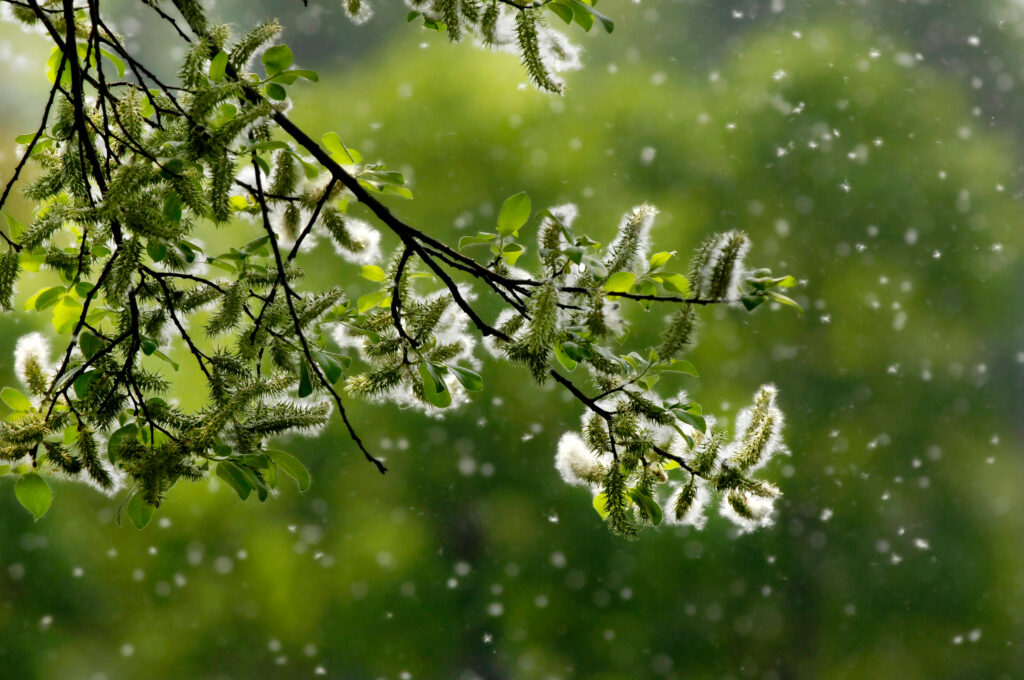
Pollen grains are tiny — typically between 10 and 100 micrometers in diameter, making them invisible to the naked eye in the air despite being clearly visible when they accumulate on surfaces as a yellow-green dust. Their size determines how they behave in the atmosphere.
Particles in this size range are subject to competing forces: gravity pulling them downward and air resistance keeping them aloft. Unlike very fine particles such as smoke or combustion aerosols, which can remain suspended in the atmosphere for days and travel thousands of miles, pollen grains are heavy enough that they settle out of the air relatively quickly under calm conditions. Most pollen released from trees falls to the ground within a few hundred meters of the source in still air.
Wind changes everything. Moving air exerts upward and horizontal forces on pollen grains that overcome gravity, lifting them from the canopy level where they’re released and transporting them laterally. The stronger the wind, the farther individual grains travel before settling. In the turbulent, rapidly-moving air of a spring weather system, pollen can be lofted thousands of feet and transported dozens to hundreds of miles from its source.
This long-range transport is why pollen from species not present in your immediate area can contribute to your allergy symptoms, and why regional pollen events — a mass flowering of oak trees across a broad area, for instance — produce atmospheric pollen concentrations that affect people well beyond the area where the trees are concentrated.
Release Timing: Why Mornings Are Worse
Pollen release from wind-pollinated trees and grasses follows a consistent daily pattern governed by temperature, humidity, and atmospheric mixing — the same factors that govern many other atmospheric processes.
Most wind-pollinated plants release their pollen in the morning, typically between 5 a.m. and 10 a.m. The mechanism is partly physical: pollen-bearing structures in flowers and catkins dry out in the morning warmth after overnight humidity, becoming brittle and opening to release pollen. It’s also partly atmospheric: the growing thermal activity of the morning — the same process that builds cumulus clouds and triggers afternoon thunderstorms — creates vertical mixing that lofts newly released pollen upward and disperses it.
This morning release peak is why allergy sufferers typically experience their worst symptoms in the morning and early afternoon rather than evening. By late afternoon, pollen released in the morning has either settled to the ground, been transported away, or been washed out by afternoon showers. Evening air tends to carry significantly lower pollen concentrations than morning air, all else being equal.
Humidity suppresses pollen release by preventing the drying of pollen-bearing structures. Mornings after rain, when relative humidity is high, produce dramatically lower pollen concentrations than dry mornings — the same plants that would release millions of grains on a dry sunny morning release far fewer when surfaces remain damp. This is why allergy sufferers often notice genuine relief on rainy days, despite the conventional wisdom that suggests rain stirs up pollen.
How Weather Patterns Concentrate and Disperse Pollen
Individual pollen grains follow the physics of atmospheric particles, but the behavior of pollen across an entire region is governed by the same weather patterns that control temperature and precipitation.
Wind direction and source regions. Because pollen travels with the wind, the direction of wind flow determines which pollen sources are upwind of any given location. A south wind across the central United States carries pollen northward from areas where spring has already advanced further and trees are further along in their flowering cycle. A north wind brings cleaner, cooler air from regions where trees are still dormant. Checking wind direction is a useful first-order predictor of relative pollen exposure on any given day.
Frontal passages. Cold fronts are the most significant weather events for pollen concentration and dispersal. Ahead of a cold front, southerly winds are typically transporting large amounts of pollen northward from more advanced spring regions, often producing the highest pollen concentrations of any point in the season. The frontal passage itself is often accompanied by rain that washes pollen from the air. Behind the front, northerly winds bring cleaner, cooler air with lower pollen loads — the post-frontal period is reliably the lowest-pollen window in the weekly cycle for most of the spring season.
This pattern explains why allergy sufferers often notice a reliable weekly rhythm to their symptoms: worsening as a front approaches and southerly flow increases, then improvement after the front clears and rain washes out the atmosphere.
Temperature inversions. On calm, clear nights, a temperature inversion frequently develops — a layer of warm air sitting above cooler surface air, which prevents vertical mixing. Pollen released the previous day can be trapped in this inversion layer overnight, concentrating near the surface by morning when new pollen release begins. Days following calm, clear nights with strong overnight inversions often have exceptionally high morning pollen concentrations as trapped overnight pollen combines with fresh morning release.
Rain and washout. Rainfall is the atmosphere’s most effective pollen removal mechanism. Raindrops collide with pollen grains and carry them to the ground — a process called washout or wet deposition. After moderate to heavy rainfall, atmospheric pollen concentrations typically drop to near zero for several hours. However, the period immediately after rain can paradoxically worsen allergy symptoms for some people: rain causes pollen grains to rupture, releasing sub-pollen particles that are smaller than intact grains and penetrate deeper into the respiratory tract.
How Pollen Forecasts Are Made
Pollen forecasting is a genuine meteorological discipline that combines botanical knowledge, atmospheric modeling, and monitoring data in ways that have improved substantially over the past two decades.
The foundation is a network of pollen monitoring stations maintained by research institutions, hospitals, and allergy practices across the country. These stations collect air samples at defined intervals, and trained analysts count and identify pollen grains under microscopy. The resulting data — pollen counts expressed as grains per cubic meter of air — forms the observational record that forecasters use.
Forecast models incorporate real-time pollen counts, plant phenology data (what’s currently flowering where, based on temperature accumulation), weather forecast data including wind, temperature, humidity, and precipitation, and known pollen transport patterns. The output is a regional pollen forecast that estimates concentrations for the following one to five days.
Modern pollen forecasts differentiate by pollen type — tree pollen, grass pollen, and weed pollen — which is useful because allergy sufferers are often sensitized to specific types rather than all pollen. In late April, tree pollen (particularly oak, birch, and maple) is at peak season across much of the country, while grass pollen season is just beginning. Weed pollen, including ragweed, won’t become a significant factor until late summer.
Using the Forecast Practically
For allergy sufferers, the atmospheric science of pollen translates into several actionable practices.
Check pollen forecasts the evening before rather than the morning of. Pollen concentrations build through the early morning, and knowing whether the next day is forecast to be high or low allows you to plan outdoor activity timing and decide whether to take preventive medication.
Time outdoor activity to avoid peak pollen windows. Early morning — before 10 a.m. — is consistently the highest-pollen period. Late afternoon and evening, after the morning’s pollen has settled and before the next morning’s release, is the lowest-pollen outdoor window on most days.
Watch for the pre-frontal and post-frontal pattern. The day before a cold front arrives is often the worst pollen day of the week. The day after the front clears — particularly if rain accompanied the frontal passage — is often the best day for outdoor activity.
Keep windows closed on high-pollen mornings even when temperatures invite ventilation. The spring ventilation article in this series recommended strategic window opening for air quality; the same logic applies in reverse for pollen management — saving ventilation for post-frontal, low-pollen afternoons rather than allowing the morning’s peak pollen concentration to settle throughout the house.
The Invisible Weather Moving Through Spring Air
Pollen is a reminder that the atmosphere carries far more than water vapor and temperature gradients. Every spring day, billions of pollen grains move through the air above us according to the same physics that governs clouds, wind, and precipitation — responding to fronts, inversions, thermals, and rainfall in ways that are entirely predictable once you know what to look for.
The allergy forecast is, in this sense, a weather forecast — one that happens to be measured in grains per cubic meter rather than degrees and inches, but driven by the same atmospheric dynamics that govern everything else about the season.