The Slow Disaster That Sneaks Up on You
Drought is the weather disaster that arrives without announcement. There is no warning siren, no radar signature, no single moment when the threat becomes undeniable. It accumulates quietly over weeks and months — a deficit of rainfall here, a stretch of above-normal temperatures there — until one day the pastures are brown, the reservoirs are at 40 percent capacity, and farmers are hauling water to livestock that have no other source.
Unlike a tornado that strikes and passes in minutes or a flood that crests and recedes over days, drought is defined by absence rather than presence. It is the sustained lack of something rather than the damaging arrival of something, which makes it simultaneously harder to recognize in its early stages and harder to end once established. Understanding the science of how drought develops, why it reinforces itself, and what it actually takes to end one is increasingly relevant as summer heat and reduced rainfall create drought conditions across parts of the country.
What Drought Actually Measures
Drought is not simply a period without rain. It is a sustained deficit of water relative to normal conditions for a specific time and place — a definition that captures something important: drought is always relative to what is normal, and what is normal varies enormously across regions and seasons.
A month with two inches of rainfall might represent a severe drought in the Pacific Northwest, where monthly averages can exceed eight inches in winter, and above-normal conditions in the desert Southwest, where two inches might be twice the monthly average. Drought is defined by departure from the expected, not by absolute precipitation amounts.
Several different types of drought are distinguished by what water system they affect. Meteorological drought is a precipitation deficit — less rain or snow than normal over a defined period. Agricultural drought occurs when soil moisture falls below what crops need for normal growth, which may lag meteorological drought by weeks as stored soil moisture is drawn down. Hydrological drought affects surface water and groundwater — streams, reservoirs, and aquifers — and may lag meteorological drought by months or years as the effects of precipitation deficits work through the water system. Socioeconomic drought occurs when water supply falls short of demand, integrating the physical drought with human water use patterns.
These distinctions matter practically. A region can be in meteorological drought but not agricultural drought if soil moisture reserves from previous wet periods buffer the precipitation deficit. It can be in hydrological drought even as meteorological conditions normalize, if groundwater recharge is slow and reservoirs haven’t recovered. Managing drought requires tracking all of these dimensions, not just whether it has rained recently.
How Drought Becomes Self-Reinforcing
The most important and least understood aspect of drought science is how drought perpetuates itself through feedback loops that make recovery far more difficult than simply returning to normal rainfall. Several mechanisms contribute to this self-reinforcing character.
The soil moisture feedback. Under normal conditions, a significant fraction of summer precipitation evaporates from moist soil and transpires through plant leaves — collectively called evapotranspiration. This evaporation and transpiration releases water vapor into the atmosphere, moistening the air and contributing to cloud formation and subsequent rainfall. In drought conditions, dry soil and stressed vegetation dramatically reduce evapotranspiration. Less water enters the atmosphere, the air becomes drier, and the conditions for rainfall formation are suppressed. The drought reduces the local moisture recycling that would normally support precipitation, making further rainfall less likely — and reinforcing the drought that caused the drying in the first place.
This feedback is measurable and substantial. Studies of major drought events have documented that a significant fraction of rainfall in humid regions comes from water that was evapotranspired locally — the Great Plains and Midwest recycle a significant portion of their summer rainfall through vegetation before it falls again downstream. When drought suppresses vegetation and dries soil, this local moisture recycling is interrupted, and precipitation deficits can persist even when the large-scale atmospheric circulation would otherwise support normal rainfall.
The albedo feedback. Dry, bare, or brown vegetation reflects more solar radiation than moist, green vegetation — a difference in surface reflectivity called albedo. Higher albedo means more solar energy is reflected back to space rather than absorbed at the surface. This changes the surface energy budget in ways that suppress the development of convective rainfall — the afternoon thunderstorms that would normally provide summer moisture. The brown landscape of a drought literally makes itself less likely to receive the rain that would end it.
The temperature feedback. Drought conditions are typically accompanied by above-normal temperatures — a relationship so consistent that meteorologists often speak of “hot droughts” as a distinct phenomenon more damaging than cool droughts. The mechanism is the same soil moisture feedback in reverse: when soil is moist, incoming solar radiation is partly consumed by evaporation, moderating surface temperature. When soil is dry, all incoming radiation heats the surface, driving temperatures higher. Higher temperatures increase evaporative demand — the atmosphere’s capacity to pull moisture from soil and plants — further depleting soil moisture and intensifying the drought.
This temperature-drought coupling explains why summer droughts tend to be accompanied by heat waves, and why heat waves intensify ongoing droughts. The 1936 Heat Wave, covered in the 5/26 historical piece, was inseparable from the drought that preceded it — the Dust Bowl drought had stripped the natural evaporative cooling from the landscape, directly amplifying the heat.
The Slow Accumulation of Deficit
Drought develops through the accumulation of a water deficit — the running total of how much less water has been received compared to what is normal. This deficit builds gradually and is measured in the Palmer Drought Severity Index, the Standardized Precipitation Index, and other tools that track how far below normal conditions have fallen and for how long.
The rate of deficit accumulation depends on both the precipitation shortfall and the temperature excess. A mild precipitation deficit during a cool period may produce only moderate drought because low temperatures reduce evaporative demand. The same precipitation deficit during a heat wave produces severe drought quickly because high temperatures pull moisture from the soil aggressively. This is why spring precipitation deficits that seem manageable can become severe droughts rapidly when summer heat arrives — the transition from cool to hot conditions dramatically accelerates the rate at which the water deficit grows.
Soil depth and soil type also affect how quickly drought develops and how resilient a landscape is to temporary precipitation deficits. Deep soils with high water-holding capacity — the kind that characterize the best agricultural lands — buffer against drought by storing water from wet periods and releasing it slowly during dry spells. Shallow, sandy, or compacted soils with low water-holding capacity develop drought stress quickly and recover slowly. This is one reason why drought impacts are spatially variable even within small geographic areas — soil differences can mean one farm develops drought stress weeks before a neighboring farm with deeper, more water-retentive soils.
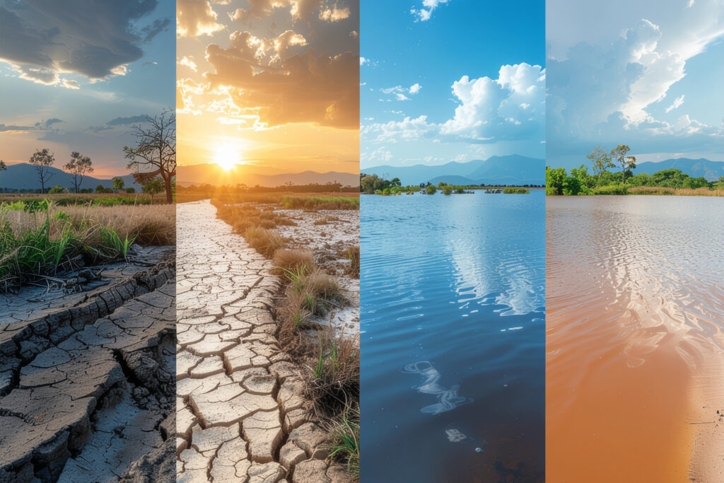
Why Rain Doesn’t Always End a Drought
The most counterintuitive aspect of drought science is that significant rainfall events can occur within a drought without ending it. This happens because drought deficits are cumulative, and a single storm — even a large one — may not be sufficient to replenish the accumulated deficit across the full depth of the affected soil and water system.
When drought-parched soil receives heavy rain, it may initially shed most of the water as runoff rather than absorbing it, because the dry soil surface can become hydrophobic — resistant to water infiltration — particularly in areas with organic matter-depleted or crusted soils. The rain that runs off enters streams and contributes to flash flooding without recharging soil moisture or groundwater. The drought may produce a flood, then persist.
Even when soil does absorb rainfall, the deficit may extend to depths that a single storm’s penetration cannot reach. Crop roots draw on soil moisture to depths of three feet or more. Groundwater recharge requires water to percolate through potentially dozens of feet of soil and rock. A storm that wets the top foot of soil provides temporary relief at the surface while deeper deficits that affect long-term water supply remain.
This is why drought recovery is measured in months and seasons rather than events. Ending a drought typically requires a sustained period of above-normal precipitation — not a single large event but repeated below-normal temperatures and above-normal rainfall across multiple months — sufficient to progressively fill the deficit from the surface downward through the full profile of the affected water system.
Monitoring and the Drought Monitor
The United States Drought Monitor — a weekly map produced collaboratively by the National Drought Mitigation Center, NOAA, and USDA — is the primary tool for tracking drought conditions across the country. The map categorizes drought intensity from D0 (Abnormally Dry) through D4 (Exceptional Drought), integrating multiple data streams including precipitation, soil moisture, streamflow, groundwater levels, and reported impacts.
The Drought Monitor is updated every Thursday and is publicly available online. It provides the most comprehensive single view of current drought conditions and is the basis for federal drought disaster declarations that trigger agricultural assistance programs. Following the Drought Monitor through summer provides context for the weather patterns — dry stretches, isolated heavy rains, the presence or absence of the typical summer storm pattern — that the daily forecast alone doesn’t convey.
The Long Shadow of Drought
Drought’s effects outlast the drought itself. Agricultural impacts extend through growing seasons that follow recovery — depleted soil organic matter, damaged perennial crops, livestock herds that were reduced during the drought. Groundwater aquifers that took decades to charge can be drawn down in a few drought years and require decades to recover. Forests stressed by drought become vulnerable to insect outbreaks and wildfire for years after moisture returns.
The self-reinforcing character of drought, its slow development and slow recovery, and its cascading effects across agricultural, ecological, and water supply systems make it arguably the most economically damaging of all weather hazards over multi-year timescales — more costly cumulatively than any individual hurricane or tornado outbreak, even if the per-event drama is lower.
Early summer is when drought conditions for the season begin to clarify. The soil moisture situation established by late spring rainfall — or lack of it — combined with the summer temperature pattern will determine whether the coming months deliver manageable dryness or the kind of sustained deficit that takes a full year or more to recover from. The Drought Monitor will track it in real time, and understanding the science behind what it shows makes the weekly map considerably more meaningful.