A Category 5 Landfall Almost No One Saw Coming in Time
Hurricane Michael made landfall near Mexico Beach, Florida, on October 10, 2018, as a Category 5 hurricane with sustained winds of 160 mph, becoming only the fourth Category 5 hurricane ever recorded making landfall in the continental United States. What made Michael particularly alarming wasn’t just its extreme intensity, but how little time existed between the storm becoming a serious threat and its catastrophic landfall, a timeline that exposed genuine limitations in how much warning even sophisticated modern forecasting can provide against a storm that intensifies with sufficient speed.
An Intensification Rate That Outpaced the Warning System
Michael underwent what meteorologists classify as rapid intensification, strengthening from a Category 1 hurricane to a Category 4 storm in roughly 24 hours as it approached the Florida coast, continuing to strengthen even further to Category 5 status in its final hours before landfall. This rate of strengthening meant that evacuation orders and preparation efforts, which typically rely on having a reasonably accurate sense of a storm’s expected landfall intensity days in advance, were working against a storm that kept exceeding its own forecasted intensity right up until landfall itself.
This timeline created a genuinely difficult practical problem: by the time Michael’s true, extreme intensity became clear, the window for a full, orderly evacuation of the Florida Panhandle region had largely already closed, leaving many residents facing a far more dangerous storm than they had prepared for based on earlier forecasts issued just a day or two before landfall.
Why Michael Intensified So Dramatically and So Quickly
Michael’s rapid strengthening was fueled by exceptionally warm Gulf of Mexico waters, including unusually deep warm water that extended well below the surface—a factor meteorologists call ocean heat content, distinct from simple surface temperature. This deep layer of warm water meant that even as Michael’s own passage churned up some cooler water from below, as hurricanes typically do in a process that can naturally limit their own intensification, sufficiently warm water remained available at depth to continue fueling the storm’s strengthening rather than the self-limiting effect that shallower warm water would have produced.
Favorable atmospheric conditions, including low wind shear and a moist surrounding atmosphere, removed the typical inhibiting factors that might otherwise have slowed Michael’s intensification, allowing the storm’s full potential, fueled by the exceptionally warm and deep ocean water beneath it, to develop essentially without meaningful atmospheric resistance.
Catastrophic Destruction in Mexico Beach and the Surrounding Region
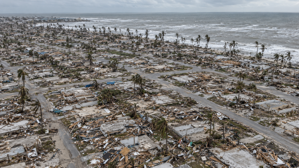
Michael’s landfall near Mexico Beach produced among the most complete, catastrophic destruction ever documented from a U.S. hurricane, with the small coastal town experiencing almost total structural devastation from the combination of extreme winds and significant storm surge. Aerial imagery of Mexico Beach in the storm’s immediate aftermath showed entire neighborhoods reduced to scattered foundations and debris fields, imagery that became among the most widely circulated and sobering visual records of the storm’s destructive power.
Beyond Mexico Beach specifically, Michael’s intense winds caused extensive damage across a wide swath of the Florida Panhandle, including significant agricultural destruction across the region’s substantial timber and farming industries, with damage estimates for the timber industry alone reaching into the billions of dollars.
A Storm That Continued Causing Damage Well Inland
Unlike many hurricanes that weaken rapidly after landfall, Michael retained considerable intensity as it moved inland across Georgia, still producing hurricane-force or near-hurricane-force winds well beyond the immediate coastal impact zone. This inland wind intensity caused significant additional damage across Georgia’s agricultural regions, including substantial impacts to the state’s cotton and pecan crops, extending the storm’s economic toll considerably beyond its coastal Florida landfall point.
What Michael Revealed About Forecasting’s Remaining Limitations
Michael became an important case study in ongoing hurricane forecasting research specifically focused on improving rapid intensification prediction. While forecasters have made substantial improvements in predicting a hurricane’s track over recent decades, accurately predicting the timing, rate, and ultimate magnitude of rapid intensification remains one of the most significant remaining challenges in hurricane forecasting, and Michael’s dramatic, late-developing intensity became a frequently cited example motivating continued research investment specifically targeting this forecasting gap.
The storm also reinforced for emergency management officials the genuine difficulty of planning evacuation timelines around a storm category that may not be accurately known until very close to actual landfall, a planning challenge that has informed subsequent discussions about how early evacuation decisions should be made relative to a storm’s current, rather than ultimately final, intensity.
A Storm That Demonstrated the Atmosphere’s Capacity to Outrun Preparation
Hurricane Michael’s legacy centers on the genuine danger a sufficiently rapid intensification rate poses, even to a region with access to modern forecasting technology and established evacuation protocols. The storm demonstrated with stark clarity that a hurricane’s threat level can change dramatically in a very short window, a lesson that continues to shape both forecasting research priorities and emergency planning conversations in coastal regions facing similar rapid intensification risk from the exceptionally warm ocean waters that made Michael possible.