The High-Pressure System That Owns the Eastern United States in Summer
If you’ve wondered why July weather across the eastern United States has a specific character — hot, humid, hazy, with afternoon thunderstorms that develop predictably and a flow of Gulf moisture that seems to never stop — the answer is a single large-scale atmospheric feature that most people have never heard of: the Bermuda High.
The Bermuda High — formally called the North Atlantic Subtropical High — is a semi-permanent high-pressure system that sits over the subtropical Atlantic Ocean. In winter, it retreats eastward toward the Azores and weakens. In summer, it expands westward, strengthening and extending its influence over the eastern United States in ways that determine the fundamental character of the summer weather season across roughly the eastern half of the country.
Understanding the Bermuda High connects the jet stream science from the 4/14 piece, the Gulf Stream science from the 6/23 piece, and the hurricane formation science from the 5/27 piece into a coherent picture of why summer in the eastern United States feels the way it does — and why some summers are dramatically different from others.
What the Bermuda High Is and How It Forms
The Bermuda High is one of five subtropical high-pressure belts that encircle the globe at approximately 30 degrees north and south latitude. These highs form through a large-scale atmospheric circulation called the Hadley Cell: warm air rises near the equator, moves poleward at high altitude, cools and descends at roughly 30 degrees latitude, and flows back toward the equator at the surface. The descending branch of this circulation creates persistent high pressure at subtropical latitudes — the same descending, warming air that suppresses cloud formation and precipitation to create the world’s major deserts at roughly 30 degrees latitude.
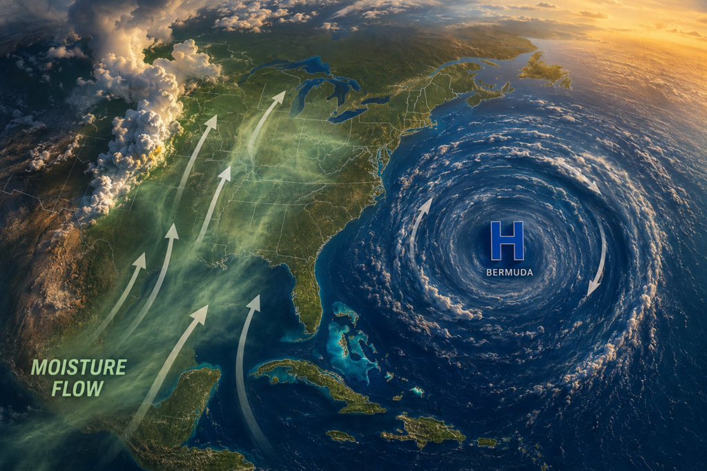
In the Atlantic, this subtropical high sits over the ocean east of North America, centered near Bermuda in summer — hence its common name. Like all high-pressure systems, it circulates clockwise in the Northern Hemisphere. This clockwise circulation has a specific and consequential effect on the eastern United States: the western flank of the high produces a southerly flow that pumps warm, moist air northward from the Gulf of Mexico across the Gulf Coast, the Southeast, and into the Midwest.
This southerly Gulf moisture flow is the source of the humidity that defines summer across the eastern half of the country. It is also the primary moisture source for summer precipitation — the thunderstorms that develop on summer afternoons are tapping the Gulf moisture that the Bermuda High’s circulation is delivering continuously from the south.
How the Bermuda High’s Position Determines Summer Character
The Bermuda High is not a fixed feature — it expands, contracts, shifts north and south, and moves east and west across seasons and years. These movements have large consequences for summer weather patterns across the eastern United States.
When the Bermuda High is positioned well to the west — extending its influence far over the continental United States — its clockwise circulation directs air from the subtropical Atlantic directly over the Southeast and up the East Coast, producing the hot, humid conditions that characterize oppressive mid-Atlantic and New England summers. The high’s western position also tends to suppress Atlantic hurricane development in the main development region by producing unfavorable wind shear across the tropical Atlantic.
When the Bermuda High sits farther east than normal, the southerly flow on its western flank is shifted eastward, potentially allowing drier air to dominate the central United States while the East Coast receives more moisture. This configuration can contribute to drought in the central Plains and Midwest while the Southeast and East Coast remain humid.
The Bermuda High’s north-south position affects where the dividing line falls between the hot, humid air to its south and the cooler, drier air to its north. In summers when the high is positioned unusually far north, the boundary between humid and dry air is pushed northward, allowing summer heat and humidity to penetrate farther into the northern United States and Canada than typical. In summers when the high is positioned farther south, the northern states may experience more frequent intrusions of cooler, drier air that moderate temperatures and reduce humidity.
The position and strength of the Bermuda High is one of the primary variables that seasonal climate forecasters assess when predicting summer temperature and precipitation patterns across the eastern United States months in advance. A strong, westward-displaced Bermuda High is associated with hot, dry summers across portions of the central United States and hot, humid summers along the East Coast. A weaker or eastward-displaced high is associated with more variable, less oppressively humid conditions.
The Bermuda High and Summer Heat Waves
The connection between the Bermuda High and summer heat waves is direct. When the Bermuda High strengthens and expands westward, it does several things simultaneously that produce heat wave conditions across the eastern United States.
It directs more intense southerly flow northward, increasing the moisture and heat content of the air mass over the affected region. It suppresses storm systems — the high pressure’s descending air inhibits cloud formation and precipitation, producing clear skies that allow maximum solar heating of the surface. It limits the penetration of cooler air from Canada by reinforcing the southerly flow and blocking the northward displacement of the jet stream that would otherwise allow cool air intrusions.
The heat waves covered in the historical pieces throughout this series — the 1936 event, the 1980 Kansas City heat wave, the 1995 Chicago heat wave, the 1988 drought summer — all involved some combination of a strengthened, westward-displaced Bermuda High and the blocking patterns that maintained its position for extended periods. The specific atmospheric mechanics that held those patterns in place varied from event to event, but the Bermuda High’s westward expansion was a common feature.
The Bermuda High and Atlantic Hurricanes
The Bermuda High plays a critical role in Atlantic hurricane tracks, as referenced in the hurricane formation piece. The clockwise flow around the high steers tropical systems that develop in the main development region — the tropical Atlantic between Africa and the Caribbean — westward toward the Caribbean and Gulf of Mexico on the high’s southern flank, and then northward and northeastward around the high’s western edge as storms move into the mid-latitudes.
A Bermuda High that is positioned farther west than normal steers hurricanes on a more westward track, increasing the threat to the Gulf Coast and keeping storms farther from the East Coast. A Bermuda High positioned farther east allows hurricanes to recurve northeastward earlier, steering them up the East Coast or out to sea rather than into the Gulf. The track of any given Atlantic hurricane is partially determined by where the Bermuda High happens to be positioned at the time of the storm’s northward movement.
This is one reason that the Bermuda High’s seasonal position is closely monitored by hurricane forecasters throughout the season. The same high-pressure system that is producing July’s humid, hazy weather is simultaneously determining where Atlantic tropical systems will track as the season progresses.
The Low-Level Jet Connection
The Bermuda High’s southerly flow on its western flank provides the background moisture transport that the Low-Level Jet — covered in the nocturnal thunderstorm piece — taps into and concentrates. The Low-Level Jet is essentially the night-time expression of the Bermuda High’s broad southerly moisture flow, concentrated and accelerated by the specific dynamics of the Great Plains boundary layer after sunset.
When the Bermuda High is strong and positioned to produce intense southerly flow, the Low-Level Jet is typically stronger and more moisture-laden, producing the nocturnal thunderstorm events that deliver the largest rainfall totals to the central United States in summer. The connection runs from the large-scale subtropical high through the regional Low-Level Jet to the individual thunderstorm cells that produce rain on a specific night — a nested set of atmospheric processes operating at very different scales but ultimately driven by the same feature.
Reading the Pattern
For readers who follow weather forecasts through the summer, the Bermuda High’s influence is visible in several specific forecast signatures.
The 500 millibar chart — the map of atmospheric pressure at approximately 18,000 feet that meteorologists use to assess large-scale flow patterns — shows the Bermuda High as a region of high geopotential heights over the subtropical Atlantic, with its western ridge extending over the eastern United States in summer. When the ridge extends unusually far west and north, the forecast discussion for the coming week will typically note “ridging” or a “strong subtropical ridge” as a factor in the hot, dry conditions expected.
The surface dew point map provides the most tangible expression of the Bermuda High’s moisture transport: when dew points across the Midwest are in the upper 60s and 70s in July, the southerly flow from the Gulf that the Bermuda High is driving is operating at full intensity. When dew points drop into the 50s behind a frontal passage, the temporary break in the Bermuda High’s influence has allowed drier air to push southward before the high reestablishes its control.
Summer in the eastern United States is, to a substantial degree, the Bermuda High’s summer. The heat, the humidity, the afternoon thunderstorms, the hurricane tracks — all of it flows from the position, strength, and circulation of this single large-scale feature sitting over the subtropical Atlantic. It is one of the most consequential weather features in the world for the people who live in its domain, and one of the least known by name.