The Fire That Makes Its Own Storms
A wildfire large enough and hot enough doesn’t just burn through weather — it creates weather. The same convective physics that produces summer thunderstorms can be driven by the intense heat of a major wildfire, generating towering smoke columns that reach the stratosphere, producing lightning that starts new fires miles from the original blaze, and in extreme cases creating fire tornadoes and pyrocumulonimbus clouds — genuine thunderstorms powered by fire rather than solar heating.
This phenomenon — pyroconvection — sits at the intersection of fire behavior and atmospheric science in a way that makes large wildfires qualitatively different from small ones. Understanding it explains why the largest wildfires are so unpredictable, why they can spread explosively in conditions that seem to defy normal fire behavior, and why the relationship between wildfire and weather runs in both directions: weather creates fire conditions, and fires create weather.
How Ordinary Convection Works — and How Fire Hijacks It
As covered in the summer afternoon thunderstorm piece, ordinary convective storms develop when solar heating warms the surface, surface air becomes buoyant and rises in thermals, and those thermals build cumulus clouds that can develop into thunderstorms. The energy driving the system is solar radiation absorbed by the ground surface.
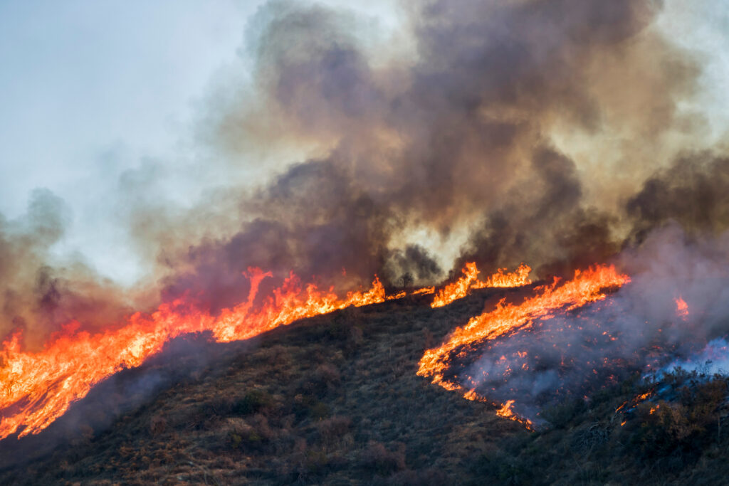
Wildfire substitutes a far more intense heat source: combustion. A large wildfire burning through dense forest or dry chaparral releases energy at rates that can exceed the solar input to the same area by orders of magnitude. This intense, concentrated heating creates a column of extremely hot air that rises rapidly — essentially a forced thermal that is far more powerful than anything solar heating produces.
The rising column draws in cooler air from the surroundings at the base — the same inflow that fans a fire and makes large fires self-sustaining. As the column rises and cools, the moisture carried from the burning vegetation and surrounding air condenses, releasing latent heat that further accelerates the updraft. If the atmosphere above the fire is sufficiently unstable — cold enough at altitude relative to the warm, buoyant fire column — the convection becomes self-reinforcing in the same way that an ordinary thunderstorm’s updraft sustains itself.
The result is a pyrocumulus cloud — a cumulus cloud generated by fire rather than solar heating — that forms directly above the burning area. Pyrocumulus clouds look like ordinary summer cumulus clouds to a distant observer, except that their base is marked by brown and gray smoke rather than clean white condensation. They form rapidly, often within minutes of a fire transitioning to extreme behavior, and can grow to impressive heights within an hour.
Pyrocumulonimbus: The Fire Thunderstorm
When conditions are right — sufficient fire intensity, atmospheric instability above the fire, and adequate moisture — pyrocumulus clouds can develop into pyrocumulonimbus: full thunderstorms powered by wildfire. This is one of the more extraordinary phenomena in atmospheric science, and its occurrence has become more frequent as climate-driven drought conditions create the dry, hot, unstable atmospheres that favor extreme wildfire behavior.
A pyrocumulonimbus cloud carries all of the characteristics of an ordinary cumulonimbus — charge separation through the interaction of ice particles and supercooled water droplets, lightning generation, and the potential for heavy precipitation — with the additional input of the fire’s combustion products. The lightning generated within a pyrocumulonimbus can strike the ground miles from the active fire, starting new ignitions in dry fuel that the original fire hasn’t reached. These lightning-started spot fires can then develop their own convection columns, further complicating firefighting operations.
The downdrafts from a pyrocumulonimbus — cold air descending from the storm’s interior — can produce outflow winds that reach the surface at 60 to 80 mph, driving the fire in new directions with explosive intensity. A fire that has been burning in a predictable direction for hours can change direction and accelerate suddenly when a pyrocumulonimbus downdraft reaches the surface, overwhelming suppression efforts and endangering firefighters who had been operating in what seemed to be safe positions.
Perhaps most dangerously, pyrocumulonimbus storms frequently produce very little rainfall at the surface. The precipitation generated within the storm often evaporates before reaching the ground in the hot, dry air below — a phenomenon called virga. The storm produces lightning, which starts new fires, without producing the rain that would suppress them.
Fire Whirls and Fire Tornadoes
Below the main convection column, the interaction of a fire’s inflow winds with complex terrain, irregular burning patterns, and the fire’s own heat creates rotational dynamics that can produce fire whirls — rotating columns of fire that range from small, brief dust-devil-scale phenomena to genuinely large and dangerous rotating fire columns.
Fire whirls form through the same process that produces dust devils: differential heating creating a horizontal temperature gradient that generates rotation, which is then stretched vertically by the rising air column into a rotating vortex. In a wildfire context, the vortex is filled with burning gases rather than dust, making it both visually spectacular and extremely hazardous to firefighters.
Most fire whirls are small and short-lived — a few meters in diameter, lasting seconds to minutes. Occasionally, conditions produce much larger events. The Carr Fire in Northern California in July 2018 generated a fire whirl that reached wind speeds estimated at over 140 mph — equivalent to an EF3 tornado — and caused structural damage to buildings and vehicles several miles from the active fire front. Meteorological analysis confirmed that this event met the criteria for a genuine tornado produced by the fire rather than by a thunderstorm — a phenomenon now called a firenado.
The conditions that produce large fire whirls are not fully understood, but they appear to involve specific combinations of fire intensity, atmospheric instability, and terrain that focus rotation in the same way that supercell thunderstorms focus rotation into mesocyclones. This is an active area of research in fire meteorology, driven by the increasing frequency of extreme wildfire events that produce unexpected rotational behavior.
How Smoke Columns Affect Weather Far From the Fire
The tallest pyroconvection columns inject smoke and combustion products directly into the stratosphere — above the weather-bearing troposphere — where they can persist for months and spread across hemispheric scales. Stratospheric smoke absorbs solar radiation, heating the stratosphere while cooling the surface below, and the optical effects can be observed thousands of miles from the original fire.
Smoke from large Canadian and western United States wildfires regularly affects air quality across the entire eastern United States, producing the hazy skies, reduced visibility, and unhealthy air quality index readings that summer residents of eastern cities have experienced with increasing frequency in recent years. This transported smoke is not pyroconvective in origin — it has been lofted into the mid-troposphere by fire columns and then carried thousands of miles by the jet stream — but the largest pyroconvective events inject material even higher, producing stratospheric layers that spread globally.
The 2019-2020 Australian Black Summer fires — which produced some of the largest and most intense pyrocumulonimbus events ever documented — injected smoke into the stratosphere at heights normally associated with moderate volcanic eruptions, circling the Southern Hemisphere and producing measurable cooling of the Southern Ocean surface over subsequent months. This represented the first documented case of wildfire-produced stratospheric aerosols of sufficient mass to produce climate-scale effects — a threshold previously associated only with major volcanic eruptions.
What This Means for Fire Weather Forecasting
The recognition that large wildfires can generate their own weather has transformed how fire meteorologists approach extreme fire behavior forecasting. The traditional model — forecasting the weather conditions that drive fire behavior and then predicting how fires will spread in those conditions — doesn’t fully capture the bidirectional relationship in which the fire modifies the atmosphere above it in ways that feed back into fire behavior.
Modern fire weather forecasting incorporates pyroconvection potential as an explicit forecast element during conditions favorable for extreme fire behavior. The Storm Prediction Center — the same center that produces severe thunderstorm and tornado outlooks during spring storm season — issues fire weather watches and red flag warnings during conditions of high fire danger, and in extreme cases produces outlooks for pyroconvection potential that alert firefighters to the possibility of explosive, unpredictable fire behavior driven by convective dynamics rather than simple wind-driven spread.
Satellite-based detection of pyrocumulus and pyrocumulonimbus clouds provides near-real-time information about fire convective activity to incident commanders and fire weather meteorologists, allowing faster recognition of the transition to extreme fire behavior and better-informed decisions about firefighter safety and resource deployment.
The Fire-Climate Connection
The increasing frequency and intensity of pyroconvective wildfire events reflects the same warming and drying trends that the 1988 drought piece described from a different angle. Hotter, drier conditions — longer dry seasons, reduced snowpack, earlier spring melt, more extreme summer heat — create the fuel conditions that allow fires to reach the intensity needed for pyroconvection. More fires reaching this intensity means more fire-generated weather events, more lightning-started spot fires, more unpredictable fire behavior, and more smoke transported into the atmospheric systems that affect weather across the country.
The wildfire that generates its own thunderstorm is not a freak occurrence. It is the extreme end of the same convective physics that produces summer afternoon storms — the same instability, the same moisture, the same updraft dynamics — powered by an energy source that drought and heat have made increasingly available across the western landscape.