That Eerie Mist Has a Very Good Explanation
Step outside on a late March or April morning and you may find the world has disappeared overnight. The trees at the end of your street are gone. Headlights float through a gray-white haze. The air feels damp and cool despite a warm forecast for the afternoon. By 10 a.m., it’s all burned off and the day is clear and bright — as if the fog was never there.
Spring fog is one of the season’s most consistent and least understood phenomena. It happens frequently, it can be dense enough to cause serious travel hazards, and then it vanishes so completely that people forget about it until the next morning. Understanding why fog forms — and why spring produces so much of it — reveals how just a few degrees of temperature difference can transform the air itself into something you can barely see through.
Fog Is Simply a Cloud at Ground Level
Fog and clouds are physically the same thing: tiny water droplets suspended in air. The only difference is altitude. When conditions cause water vapor to condense into droplets at ground level rather than thousands of feet up, the result is fog. Walking through fog is, literally, walking through a cloud.
For fog to form, the air must cool to its dew point — the temperature at which air becomes saturated with water vapor and can no longer hold all of its moisture in invisible gaseous form. When air cools below the dew point, the excess vapor condenses into tiny liquid droplets. If enough droplets form near the ground, visibility drops and fog is the result.
The question of why spring produces so much fog comes down to understanding what cools the air to its dew point so reliably on spring nights and mornings.
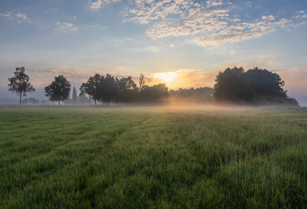
Radiation Fog: The Most Common Spring Variety
The fog that blankets spring mornings most often is called radiation fog, and it forms through a beautifully simple process. After sunset, the ground begins radiating the heat it absorbed during the day back out to space. On calm, clear nights — exactly the kind of nights that often follow warm spring days — this radiative cooling proceeds rapidly with nothing to interrupt it. No cloud cover to trap warmth near the surface. No wind to mix cooler and warmer air layers together.
As the ground cools, it chills the air immediately above it. That air cools toward its dew point. Spring air carries significantly more moisture than winter air — the warming temperatures allow more water vapor to exist in the atmosphere — which means the dew point is higher. A higher dew point means air doesn’t have to cool as much before condensation begins.
By early morning, the air near the ground has often cooled just enough to reach that elevated spring dew point, and fog forms in a shallow layer hugging the surface. Valleys and low-lying areas are especially prone because cold air, being denser, drains downhill and pools in depressions — concentrating the cooling effect exactly where fog forms most easily.
Why Spring Has More Fog Than Winter
This might seem counterintuitive. Winter is colder, so shouldn’t it produce more fog? The answer is no — and the reason explains a lot about how fog works.
Fog requires a specific combination: enough moisture in the air AND enough cooling to bring that air to its dew point. Winter air is cold, but it’s also very dry. Cold air holds much less water vapor than warm air, so winter dew points are low. Cooling the air to a low dew point is easy, but there aren’t enough water droplets available to create dense, visible fog.
Spring air is the sweet spot. It’s warm enough to carry substantial moisture — dew points regularly climb into the 40s and 50s — but nights still cool significantly, sometimes by 20°F or more between afternoon highs and early-morning lows. That large temperature swing, applied to moisture-rich spring air, is the perfect recipe for radiation fog.
Summer mornings are sometimes foggy for similar reasons, but summer nights often don’t cool as dramatically, limiting how frequently conditions reach the dew point. Spring’s combination of large day-to-night temperature swings and rapidly increasing atmospheric moisture makes it the foggiest season of the year across much of the country.
Advection Fog: When Warmth Meets Cold Ground
Spring also produces a second type of fog through a different mechanism. Advection fog forms when warm, moist air moves horizontally over a surface that is still cold from winter.
This happens frequently in spring when warm, humid air pushes north across regions where the ground — and particularly bodies of water — haven’t fully warmed yet. The Great Lakes, coastal areas, and even large fields still chilled from snowmelt can be cold enough that warm air flowing over them loses heat rapidly from the bottom up, cooling to the dew point and producing fog.
This is why coastal areas and lakeshores are often the foggiest places in spring even on days when inland areas are clear. The water temperature lags weeks behind air temperature — the lake that was 34°F in February might still be only 42°F in late March, cold enough to chill warm spring air into fog as it passes overhead.
Advection fog can persist longer than radiation fog and doesn’t necessarily burn off with morning sun, because its source — the cold surface below — remains cold throughout the day until the season advances further.
Why Fog “Burns Off” in the Morning
The disappearance of morning fog is as satisfying to watch as a time-lapse, and the process behind it is straightforward. As the sun rises and begins heating the ground, the surface warms and transfers heat back to the air above it. The air temperature rises above the dew point, and the tiny water droplets that form fog evaporate back into invisible vapor. The fog doesn’t go somewhere — it simply ceases to exist as liquid water, reverting to the gaseous state the rising temperature allows.
Fog typically burns off from the top down and from the edges inward, which is why you sometimes see a fog layer thinning and lifting rather than vanishing all at once. As the sun angle increases through the morning, solar energy reaching the surface increases rapidly, and fog that might persist for hours on a cloudy day can vanish within 30 minutes on a sunny spring morning once the sun climbs high enough.
Fog’s Practical Impacts — and One Surprising Benefit
Dense fog is a genuine hazard. Visibility below a quarter mile significantly increases the risk of vehicle accidents, and fog-related crashes kill hundreds of people in the United States each year. The National Weather Service issues Dense Fog Advisories when visibility is expected to drop to a quarter mile or less, and these should be treated with the same seriousness as any other weather warning. Slowing down, increasing following distance, and using low-beam headlights (not high beams, which reflect off fog and reduce visibility further) are essential precautions.
But fog also provides something the spring landscape genuinely needs: moisture. Fog drip — the process by which fog droplets collect on leaves, needles, and other surfaces and drip to the ground — can deliver meaningful amounts of water to ecosystems and gardens, especially in areas where spring rainfall is limited. Coastal redwood forests in California depend on summer fog for a significant portion of their annual water budget. On a smaller scale, your garden benefits from a dense spring fog in ways that don’t show up in the rain gauge but are real nonetheless.
A Season That Transforms Overnight
Spring fog is a reminder that the most dramatic weather isn’t always the most violent. A fog-shrouded morning transforms the familiar into something otherworldly — the same neighborhood made strange, the same drive to work turned eerie and slow. It forms through nothing more than a few degrees of temperature change and a bit of moisture in the air, and it disappears just as quietly.
That it happens most often in spring, the season already defined by transformation, feels entirely appropriate.