Understanding the Atmospheric Conditions That Create Low-Visibility Conditions
Drive to work on a winter morning and visibility suddenly drops to a few hundred feet as dense fog blankets roads, fields, and neighborhoods. An hour later, the fog has completely burned off and the day is clear. Winter morning fog is a common phenomenon that results from specific atmospheric conditions involving overnight cooling, moisture in the air, and the relationship between temperature and dew point. Understanding why fog forms—and why it appears most frequently on certain types of winter mornings—reveals fundamental principles about how the atmosphere holds and releases moisture.
What Fog Actually Is
Fog is simply a cloud that forms at ground level. Like clouds higher in the atmosphere, fog consists of tiny water droplets suspended in air—small enough to remain airborne rather than falling as precipitation.
Fog forms when air temperature drops to the dew point—the temperature at which air becomes saturated with water vapor and can’t hold any additional moisture. When saturation occurs, excess water vapor condenses into liquid droplets, creating visible fog.
The key to understanding fog formation is recognizing that warm air can hold much more water vapor than cold air. As air cools, its capacity to hold moisture decreases. Eventually, cooling air reaches a temperature where it’s holding exactly as much moisture as it can—the dew point. Any further cooling forces moisture to condense out of the air as tiny droplets.
Radiation Fog: The Most Common Winter Type
The fog you encounter on clear, calm winter mornings is typically radiation fog, formed through a specific process:
Clear skies allow radiational cooling. After sunset, Earth’s surface radiates heat energy outward toward space. Without clouds to trap and re-radiate this heat back down, the ground cools rapidly throughout the night.
Ground cools the air layer above it. As the surface loses heat, it chills the air directly in contact with it. This coldest air settles at ground level because cold air is denser than warm air.
Air temperature drops to the dew point. If the air contains sufficient moisture, continued cooling eventually brings temperature down to the dew point. When this happens, water vapor condenses into fog droplets.
Calm winds are essential. Light or calm winds allow the coldest air to remain at ground level where fog forms. Strong winds would mix the air column, bringing warmer air from above down to ground level and preventing the surface layer from cooling enough for fog formation.
This is why radiation fog typically forms on clear, calm nights—these are the conditions that allow maximum radiational cooling with minimal mixing.
Why Winter Mornings Are Prime Fog Time
Several factors make winter mornings particularly prone to fog formation:
Long nights provide extended periods for radiational cooling. December and January nights might last 14-15 hours in temperate latitudes, giving surfaces plenty of time to cool and chill the air above them.
Moist air from rain or snow earlier in the day or previous days leaves elevated moisture levels in the air. Winter precipitation events that leave ground wet or snow-covered provide moisture that evaporates into the air.
Temperature-dew point convergence happens readily on winter mornings. Overnight cooling doesn’t need to be extreme—just enough to bring temperature down to the dew point, which might already be relatively close to air temperature.
Temperature inversions are common in winter, where cold air settles in valleys and low areas while warmer air remains aloft. This stable layering prevents mixing and allows dense fog to form in low-lying areas while hilltops remain clear.
Why Some Mornings Have Fog and Others Don’t
Not every winter morning produces fog, even when conditions seem similar:
Moisture availability is critical. Dry air can cool to extremely low temperatures without forming fog because there’s insufficient water vapor to condense. Following dry periods without recent precipitation, fog is unlikely even on clear, calm nights.
The temperature-dew point spread determines whether fog forms. If evening temperature is 40°F and dew point is 38°F, just 2°F of overnight cooling creates fog. If temperature is 40°F and dew point is 25°F, cooling to 25°F would be required—unlikely except in extreme cold snaps.
Wind conditions must be calm or nearly calm. Even light winds of 5-10 mph can prevent radiation fog by mixing air layers enough to prevent the ground-level cooling necessary for fog formation.
Cloud cover dramatically affects fog formation. Overcast skies prevent radiational cooling, keeping nighttime temperatures warmer and often preventing temperature from reaching dew point.
This explains the pattern you might notice: fog often follows clear nights after rainy days when moist air is present, skies are clear for radiational cooling, and winds are calm.
Valley Fog and Cold Air Drainage
Topography plays a major role in fog formation:
Cold air drains downhill because it’s denser than warm air. On calm nights, cold air flows into valleys, hollows, and low spots, accumulating in the lowest areas.
Valley floors become significantly colder than surrounding hillsides through this cold air drainage, often by 10-20°F or more.
Fog forms in valleys and low spots while hilltops and ridges remain clear. Drivers descending into valleys often encounter sudden dense fog while areas just a few hundred feet higher remain fog-free.
Rivers and streams in valleys provide additional moisture, making valley fog even more common and persistent.
This is why weather forecasts often mention “patchy fog in valleys” or “dense fog in low-lying areas”—it’s recognition that topography creates localized fog zones.
When Fog Burns Off
The term “burning off” describes fog dissipation, though no actual burning occurs:
Sunlight warms the ground after sunrise, and the warmed surface heats the air layer immediately above it.
Temperature rises above dew point. As air warms, it can hold more moisture, so the existing water droplets evaporate back into invisible water vapor.
Fog lifts and dissipates from the bottom up. The surface layer warms first, clearing fog at ground level while fog may persist at slightly higher elevations for a time before it too evaporates.
Burn-off timing depends on sun angle and intensity. Strong late-morning sun on a January day might clear fog in 1-2 hours. Weak early-morning sun in December might take 3-4 hours or longer.
Thick fog takes longer to dissipate than thin fog because there’s more condensed moisture that must evaporate.
On overcast days when sun doesn’t break through, fog may persist all day, only clearing when wind increases to mix the air column or when weather patterns change.
Freezing Fog: A Winter Hazard
When fog forms at temperatures below 32°F, droplets are supercooled—liquid despite being below water’s normal freezing point:
Freezing fog occurs when temperatures are in the 20s or lower but conditions still favor fog formation.
Droplets freeze on contact with surfaces like roads, cars, trees, and power lines, coating everything in a layer of ice called rime ice or frost.
Roads become treacherous as freezing fog deposits clear ice on pavement—essentially creating black ice conditions that develop gradually during foggy conditions rather than from precipitation.
Visibility and icing combine to create extremely dangerous driving conditions. Limited visibility would be hazardous enough, but ice-covered roads compound the danger significantly.
Freezing fog warnings from weather services indicate these particularly hazardous conditions and should be taken seriously.
Fog vs. Mist vs. Haze
Several terms describe reduced visibility, with technical distinctions:
Fog reduces visibility to less than 5/8 mile (1 kilometer). It’s dense enough to significantly impair vision and travel.
Mist consists of water droplets like fog but is less dense, reducing visibility to between 5/8 mile and 6 miles. Mist is thin enough that you can usually see through it reasonably well.
Haze is reduced visibility from dry particles—dust, smoke, pollution—rather than water droplets. Haze can persist on hot, dry days when fog would be impossible.
The distinction matters for weather forecasting and aviation, but in common usage, people often use these terms interchangeably.
Advection Fog: The Other Winter Type
While radiation fog dominates winter mornings, another fog type occurs in winter, especially in coastal areas:
Advection fog forms when warm, moist air moves over a cold surface—typically when mild air flows over snow-covered ground or cold ocean water.
The moving air cools from contact with the cold surface. If it cools to its dew point, fog forms.
Advection fog can occur anytime, day or night, because it’s driven by air mass movement rather than nighttime cooling.
Thicker and more persistent than radiation fog, advection fog can blanket areas for days if weather patterns persist.
Coastal areas experience advection fog year-round when warm, moist ocean air moves over cold coastal waters or when warm air masses move inland over snow-covered landscapes in winter.
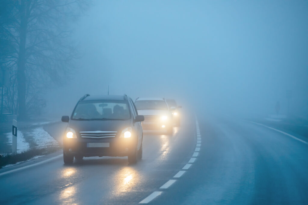
Driving in Dense Fog
Fog creates some of winter’s most hazardous driving conditions:
Reduce speed significantly. The limited visibility means much less reaction time for obstacles, stopped vehicles, or changing road conditions.
Use low-beam headlights. High beams reflect off fog droplets and reduce visibility further. Low beams illuminate the road better in fog.
Increase following distance dramatically. You need much more space to stop when you can’t see far ahead.
Use fog lights if equipped, as they’re positioned low and aimed to illuminate the road surface without reflecting off fog.
Don’t use hazard lights while driving—this confuses other drivers about your intentions and makes brake lights less noticeable.
Consider delaying travel if fog is extremely dense. Dense fog warning means visibility under 1/4 mile—genuinely dangerous conditions where travel should be avoided if possible.
Forecasting Fog
Meteorologists predict fog by analyzing the temperature-dew point relationship and expected overnight conditions:
Small temperature-dew point spread (3-5°F or less) in the evening suggests fog is likely if other conditions align.
Clear skies and calm winds forecast overnight create prime radiational cooling conditions.
Recent precipitation ensures moisture availability for fog formation.
Areas prone to fog based on topography can be specifically highlighted in forecasts.
However, fog forecasting remains challenging because small variations in wind, cloud cover, or moisture can prevent expected fog from forming or cause unexpected fog to develop.
A Regular Winter Visitor
Winter morning fog is a normal atmospheric phenomenon wherever conditions align—cool overnight temperatures, clear skies, calm winds, adequate moisture, and topography that favors cold air settling. Understanding this isn’t mysterious weather but rather predictable physics—air cooling to its dew point and condensing moisture into visible droplets—helps you anticipate when fog might form and recognize the conditions that make some winter mornings crystal clear while others shroud everything in gray obscurity.
That dense fog you drive through on January mornings isn’t random chance. It’s the atmosphere’s way of showing you what happens when temperature meets dew point at ground level on a clear, calm winter night—invisible water vapor becoming visible, air becoming cloud, and visibility disappearing until the sun rises high enough to warm things back up and turn those fog droplets back into the invisible moisture from which they came.